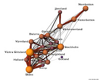
The thing below is a map of sorts. Not the prettiest thing you'll ever see and only "waguely" understandable. Still it would be cool to see it as a 3D model so you could look from all angles and see all the different connections. I forget where I originally found it but it's posted on
Flickr. If you click it it will tell you in the title that it shows "Road Traffic" between Swedish counties, however a reading of the text below indicates that it is actually showing the tonnage of goods transported. You will also get some more info and the author (
Arenamontanus).
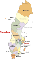
Not knowing my Swedish counties as well as a geographer should I downloaded the county map below right from
World Atlas. Note that there is at least one mistake on the county map - Dalarna County is labeled Kopparberg which is actually a town located in adjacent Orebro County.
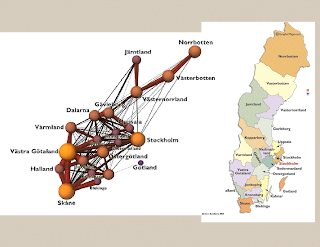
Realizing that this blog layout doesn't lend itself to looking at these maps side by side I took the liberty of making my own image to compare the two maps - Click below to get a larger image - if that helps any.


2 comments:
Kinda interesting that all of that traffic up north doesn't go all the way south to the core of the country. I wonder if northern Sweden is more connected to the port of Trondheim, in Norway?
My guess is that the highway network doesn't easily link the northern and southern provinces. Ever try driving a truck through Ljusdal? Me neither.
Post a Comment