Wednesday, November 27, 2013

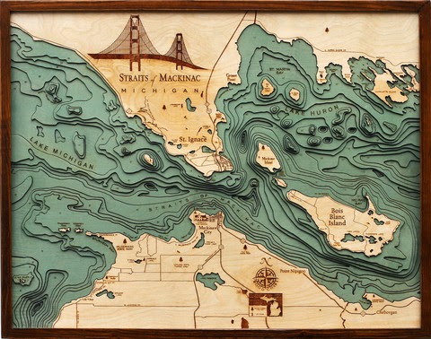
Wooden Bathymetry

Below the Boat sells wooden charts made by laser cutting contour lines from bathymetric charts. They feature maps of various coastal areas and lakes such as Lake Tahoe,
http://www.belowtheboat.com/products/lake-tahoe
http://www.belowtheboat.com/products/san-juan-islands 
http://www.belowtheboat.com/products/straits-of-mackinac
http://www.belowtheboat.com/products/virgin-islands
and many more. Explore their gallery and you'll see lots of pictures of cute pets posing with their maps.

Wednesday, November 20, 2013

Kennedy Assassination Infographic

Friday will be the 50th anniversary of the Kennedy Assassination. I am not well versed in the conspiracy theories. Reuters produced a good infographic/map showing the layout of Dealey Plaza that helps clarify the events.
I don't know when or where this image was originally published but there is a nice interactive version of it on speakingimage where you can zoom, pan and click a few points for details.

Friday, November 15, 2013

The Cloud Corridor-Srsly?

Neighborhood rebranding is popular with real estate people. Newer, cuter names will sell more property. Now the technology sector in San Francisco is coming together to try and rebrand several distinct neighborhoods into a Cloud Corridor.
If your business is in this area they want you to start using the Cloud Corridor term in marketing materials, press releases, twitter hashtags and in general conversation. Their San Fran. style self congratulatory rhetoric tells of how they have replaced the Silicon Valley as the new "hub of innovation" and with this rebranding "can capture the hearts and imaginations of the local talent and the wider world."

Of course this area covers much of downtown San Francisco so I suspect the huge number of non-cloud business owners, employees and residents in this "corridor" may not be too happy about being rebranded. Also, the cloud-shaped boundaries on this map look kind of silly. The metaphor doesn't work if you consider that the areas "in the cloud" are the negative space (the rest of the city.) Finally why did they extend the corridor off the map to the west where there are no googledots? Are they suggesting unlimited future growth?


Wednesday, November 13, 2013

Nature's Toll on the Philippines

National Geographic has an excellent map showing all the problems nature causes for the Philippines. Not only are the islands magnets for huge typhoons, they also have to cope with earthquakes, volcanoes and landslides. The light brown lines represent a mere 10 years of storm tracks.
http://news.nationalgeographic.com/news/2013/11/131111-philippines-dangers-haiyan-yolanda-death-toll-rises/
The islands are located in a very warm part of the Pacific with no major land masses to the east so they get the full force of these storms. More than 60 percent of the population lives in coastal zones, often in poorly constructed housing. High rates of poverty mean that many people have little control over their living situations. Deforestation has caused mudslides which in turn create sediment clogged stagnant water leading to outbreaks of cholera. On top of all of this, the Philippines are located in the Pacific "ring of fire" where volcanoes, earthquakes and tsunamis are common.

For a more complete summary of their precarious situation see the National Geographic article.

Thursday, November 7, 2013

The Great Lakes Storm of 1913

100 years ago today was the beginning of the Great Lakes Storm, the most deadly and destructive storm to ever hit the region. Also known as the "White Hurricane" because of the blinding snow that fell, the storm killed over 250 people, destroyed 19 ships and stranded 19 ships and some additional cargo barges. The storm raged for several days with a few lulls that only served to give false hope to stranded mariners. Most of the destruction occurred in Lake Huron. Wikipedia has this excellent map, originally from the USGS showing sunken ships in black and stranded ones in gray. Click for the original, more readable image.
The storm intensified and built up to hurricane force on November 9th. The US Weather Bureau only issued reports twice a day so most of this build up was not noted until too late. Cleveland saw 22 inches of snow and lost power for days as did much of the region. Breakwaters were destroyed in Chicago and Milwaukee.
   
There is a story on NPR's Morning Edition on the search for two ships in Lake Huron that have never been found. Another interesting account of the attempts by some crews to survive can be found in The Paragraph.