
Rand McNally is a giant in the world of cartography, dominating the US market during the pre-internet era and still producing maps and road atlases as well as being a player in the fleet management, connected vehicle and educational markets. The company began as a printing shop in Chicago in 1856. According to company lore (via Wikipedia) the business survived the Great Chicago Fire by burying two printing machines in a beach on Lake Michigan.
In the 1860's they began printing railroad timetables and in 1872 produced their first map as part of their Railroad Guide.
 The Library of Congress has some nice examples of their early maps. Before they developed a standardized look their maps had all kinds of creative details. This giant finger, for example, is kind of awesome.
 This map, Colonists' and emigrants' route to Texas has some wonderful townscapes, though I'm not sure how accurate they are or were at the time.
 What I really like though is this transition from a traditional continental-scale railroad map to the larger scale pictorial map of Texas right at the border.
 Texas is a REALLY BIG state! Here is what the whole map looks like.
 Galveston, with its steam ship lines.
 One final detail of this map that I like is the water lines.
 Here is some really nice topographic and road detail from their 1877 northern Black Hills map.
 The map features illustrations along the sides including this classic stereotype.
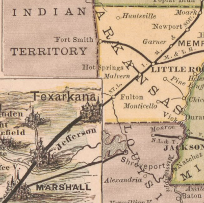
 The company began producing atlases in 1876. "Printed in colors from plates secured by letters patent, producing the clearest typographical effect of any known engraved plates." Here is a sample from the 1878 Business Atlas, later known as the Commercial Atlas & Marketing Guide. The maps are beginning to show a standardized style.
 In the pre-auto age these atlases emphasized the railroads (the dark lines). The current Road Atlas, shows motor vehicle routes while not showing railroads at all.

In the 1860's they began printing railroad timetables and in 1872 produced their first map as part of their Railroad Guide.


No comments:
Post a Comment