This map from
Margaret Pearce appears in the latest
High Country News.
The article details how the Morrill Act created land grant universities by confiscating Native American land (in purple above). Here is a detailed view since the map above is hard to read at this size.
Interestingly the land seizures were not just for college campuses but also lands far away that were taken to grow the university endowments. This map shows parcels of land owned by the University of California. Another map shows Cornell's lands stretching all the way across the country.
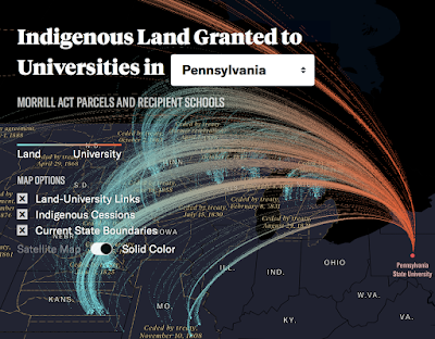
There is now an
interactive website where you can choose a school and see the lands ceded with some nice looking 3D graphics.
Here a map of many colored dots shows
lands taken in the treaties of Mendota and Traverse des Sioux in 1851, relinquishing nearly all Dakota territory in Mni Sota Makoce, “The Land Where the Waters Reflect the Clouds.” The treaty was signed only after withholding rations, threats of violence, and the destruction of agriculture and game.
Many more great maps and the article are
here, and there's a lot to explore on the
interactive website


No comments:
Post a Comment