Wednesday, October 27, 2021

More Cross Stitch Maps

 One of the talks I enjoyed at this month's North American Cartographic Information Society Conference was from Kara Prior, who uses maps to create cross stitch pattern designs - on sale on her Etsy shop.

She details the process in her talk - now available on YouTube. The idea is to take a map and make it as low resolution as possible while still conveying information. That way you see the individual squares. Here is a screen shot from the video illustrating this.

One of my favorites is the bedrock geology of Arizona. The colors really jump out - some of them look like they were taken from the state's flag.

 
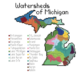
She also has bathymetry and watersheds as well as several other, non-map patterns. The watersheds can be quite simple such as New Jersey,

or much more complicated.

I'll end with some bathymetry examples


Wednesday, October 20, 2021

Chosin Reservoir Medal of Honor Map

Last week I attended the North American Cartographic Information Society Conference in Oklahoma City-virtually. There are always many inspiring maps to see there and I will likely be highlighting a few over the next few months. Here is a map by cartographer Gene Thorp showing the recipients of the Medal of Honor at the Battle of Chosin Reservoir in the Korean War.


The gold stars are the best available locations of the actions that thirteen service members were awarded for. The battle was a turning point in the early part of the Korean War when the Chinese entered the war and drove UN forces out of North Korea through treacherous frozen mountainous terrain. Thorp used terrain from Google Earth and shows a winter-time scene that does a good job of conveying the conditions. The map was exported to Adobe Photoshop and Illustrator where the annotation was created. 

This map is used by the National Medal of Honor Museum to visualize the extreme conditions these award recipients went through.


Wednesday, October 13, 2021

The Federal Republic of Central America

In September, 1821 Central America became independent from Spain. The newly formed nation, ruled from Guatemala, dissolved quickly as the countries were not able to unify and were absorbed by Mexico. After Mexico has its own political problems, the Republic of Central America was formed in 1823.

It only lasted until 1840 after Nicaragua, Honduras and Costa Rica separated and formed their own countries. Note that a large chunk of Nicaragua was part of Honduras at the time of this map. This area, the Mosquito (or Miskitu) Coast was part of a British protectorate, then was variously part of the two nations and now split between them. Here is a map of the area as an autonomous region.