Wednesday, August 30, 2023

The New Acadian Heritage Room

 On my recent trip to Nova Scotia, I stumbled upon the grand opening of the New Acadian Heritage Room at the O’Dell House Museum in Annapolis Royal. I had not known anything about it, but was in the right place on the right day. The room is primarily a collection of maps from the Acadian period between 1686 and 1755. 

There are only about 9 maps but they are beautifully illustrated and highly detailed. Above is a photo I took from the earliest map of the French houses of Port Royal (renamed Annapolis Royal by the British for Queen Anne) and “where a considerable town can be made”. This “very exact” map is at the Bibliotheque Nationale de France (BNF) and can be seen completely online here.


Above is a detail of the fort and town from the “Plan de la riviere du Dauphin et du fort du Port Royal a l'Acadie en 1710”. Like the town, the Dauphin River was (I assume) renamed the Annapolis River when the British took control of the area. This map is also available from the BNF and can be seen here. It is worth a look to see the detailed close ups of the fort and river mouth as well as a linear depiction of the entire lower course of the river at the bottom.

Here is another nice detail of the town from a map that I did not document well enough to provide much more information on.

From the Annapolis Heritage Society Archival Collection, here is a 1744 map by “N. B. Ing De la M.”

Finally, from the same archives here is a somewhat darkly photographed “Part of North America including the Harbor of Annapolis Royal” by Nat Blackmore, 1712.

If you’re in the Annapolis Valley of Nova Scotia and want to get your fill of historic maps, a trip to the O’Dell House is highly recommended.

Wednesday, August 23, 2023

Some Maps in the Wild: Nova Scotia Edition

There is an entire web site dedicated to #MapsintheWild - also a social media hashtag. On a recent trip to Nova Scotia, I found some very nice examples, including last week's post. Here are a few more. 

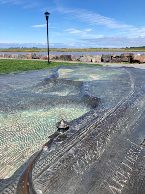
There are many memorials throughout the province to the Acadians who were expelled from Canada (also from Maine) by the British starting in 1755. Here is a map found along the Halifax waterfront showing migration and expulsion routes.

Also on the waterfront is Cable Wharf, the endpoint of a 3,200 kilometer long cable under the Atlantic Ocean that connected Europe to North America. This large cylindrical monument (like a spool of cable) includes a map of the transatlantic cables that wraps around the entire cylinder.

Though almost impossible to adequately photograph here is my attempt at a close up of part of the map. The cables are dashed lines that are very hard to see.

Finally, in Wolfville, near the Bay of Fundy, there is a large piece called Work at the Trestle. This bronze sculpture by Ruth Abernethy features T. T. Vernon Smith, civil engineer and builder of the Windsor and Annapolis Railway looking over a map showing damage to the railway after a huge storm in 1869. More on this monument can be seen here.

Here I am looking over his shoulder.

Again a work this large is tough to photograph in a meaningful way. Here is a little bit of the map detail. 

Here is the work shown in context at the waterfront park. The gazebo shown on the sculpture is just to the right of the photo.


Wednesday, August 16, 2023

Nova Scotia Map Mural

 I’m in Nova Scotia this week in places with poor internet so I was not planning on posting anything. Then I saw this fantastic mural on the side of a building in Annapolis Royal so I just had to share it. Enjoy!


Wednesday, August 9, 2023

Tyne River Shipbuilders

While researching something unrelated, I came across this series of maps showing ship builders and related industries on the River Tyne in and near Newcastle, UK. 

The maps, from 1972, stretch from the mouth of the river (above) to the City of Newcastle upon Tyne,

and westward to Heddon-on-the-Wall, that wall being Hadrian's Wall. The river has been somewhat straightened to fit the rectangular format of the map. The bottom panel lists the bridges with their height and also has a table of distances to the seaward end of the river.

Explore it all here.

Wednesday, August 2, 2023

The Film Industry's Nine Dash Line Problem

This summer's hit movie Barbie has been banned in Vietnam for its portrayal of the Nine Dash Line on a world map. Note: I have not (yet) seen any of the movies or shows listed below.

This line represents China's claims in the South China Sea. These claims have been rejected by the United Nations. In the above image, via Vox, it is the white squiggle to the right of Asia. Here is the line on a map from the Daily Mail.

The inclusion of this line on a very stylized, child-like map that is clearly not meant to be accurate is curiously unnecessary. The speculation in many articles was that the line was added to appease Chinese government censors and open the movie up to the huge Chinese market. This is not the first controversy about the Nine Dash Line on screen. Disney's movie Abominable also shows this line in a scene that was ordered removed by the Malaysian government and was also boycotted by Vietnam.

Image from YouTube

The Philippine government banned two episodes of the Netflix series Pine Gap for showing this line on maps. The line in the image below is barely noticeable but it is there in red.

Image via Radio Free Asia-cropped to better fit this space

The movie Uncharted was also banned in Vietnam for use of an "illegal image" of a map. This two second frame shows the same line.

The image above is from an (pre-Barbie) article in Esquire titled Every Time Hollywood Messed Up and Displayed China's Illegal Nine Dash Line on Screen. This article shows more stills of these maps including one from Crazy Rich Asians that appears on a designer handbag. It does not show the line but still ran afoul of the Vietnamese censors.