The British Library contains over 4.5 million maps, atlases, globes, and digital models dating back to medieval times. A small sample of these are displayed on the walls in a section called "Maps & Views". Here are some mediocre pictures I took with links (where I can find them) to online resources. As the British were the ultimate colonizers, here are a few maps from their colonial empire.
Plan for a New Capital, Punjab - when Pakistan was split off from India, the state of Punjab was divided between the two with the capital, Lahore on the Pakistan side. India needed a new state capital for East Punjab and the Prime Minister Nehru hired Le Corbusier to design it in a grid pattern. He conceived the Chandigarh Master Plan as analogous to human body, with a clearly defined head (the Capitol Complex), heart (the City Centre), lungs (the leisure valley, and open spaces), the intellect (cultural and educational institutions), circulatory system (roads), etc. More details about this map can be found on this page from Planning Tank.
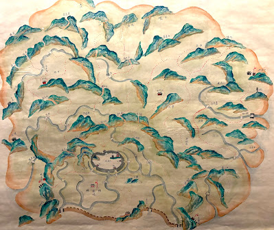
Gertrude Bell's Military Intelligence Map - Gertrude Bell was an English writer, administrator and archaeologist who spent much of her life exploring the Middle East. She was influential in the founding of Iraq. She was summoned to the area during World War I and recorded the positions of features on the land using surveying equipment. Red diagonal lines show her path of travel, while details from subsequent travelers were added later. You can read more about her life and maps in this Library of Congress blog post.Map of the county of Dinghai in the Island of Zhoushan - Zhoushan is an island south of Shanghai that the British captured and lost few times during the Opium Wars and attempted to colonize as a major trading port. The walled area is the city of Dinghai. There is no credit that I can find for the map's author but the rendering of mountains is truly unique. Some of them look like jumping dolphins. I have not found this exact map online but there is a similar version at the Reading Digital Atlas.


No comments:
Post a Comment