The salt front is the point where a river becomes too salty to be safe for drinking water. The front moves upstream from the river’s mouth as less freshwater flows downstream to dilute it. I’d never heard of a salt front until I read about it in a recent article in the Philadelphia Inquirer. The region’s severe drought in November caused this front to move significantly further upstream than the median monthly location.
On the map above, via the Delaware River Basin Commission (cropped for ease of reading), the pink area is the median salt front location and the pink arrow shows the normal location of this front in November, near Wilmington, Delaware. The blue arrow shows the location as of November 18, 2024.
The DRBC monitors freshwater flows to keep the salt front from migrating too far upstream. This protects drinking water and industrial water intakes. There are major drinking water intakes for both Philadelphia and New Jersey at the blue box on the map. One way to keep freshwater flowing is to release water from various upstream dams.
The worst droughts were in the mid 1960’s-this shot from one of their videos shows the most upstream movement of the front on November 20, 1964,
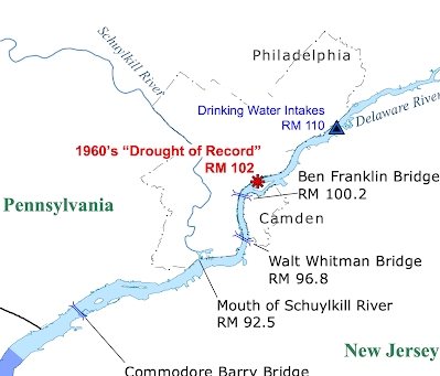
and here is a still map showing more specifically the salt front’s furthest upstream location during the “drought of record”
Finally, here is a screen shot from the hydrologic conditions dashboard, showing conditions on November 23, 2024.


No comments:
Post a Comment