Wednesday, May 15, 2024

Radical Atlas of Ferguson, USA

Coming out this summer from Belt Publishing (publishers of the "50 Maps" book series on Cleveland, Detroit and Buffalo) is the Radical Atlas of Ferguson, USA.  

"Ferguson, Missouri, became the epicenter of America’s racial tensions after the 2014 murder of Michael Brown and the protests that followed in its wake. Though this suburb just outside St. Louis might have seemed like an average midwestern town, the activism that exploded there after Brown’s killing laid bare how longstanding municipal planning policies had led to racial segregation, fragmentation, poverty, and police targeting." - quoted from the press release.

Author Patty Heyda uses over 100 maps to illustrate the forces that have defined "inner ring" suburbs such as Ferguson. Beginning from the start of the development of the St. Louis region, here is part of a map showing the confluence of rivers and trade routes. The rivers are sized by flow.

NOTE: these maps are chosen from what has been shared with me in press releases.

 The above map shows how different neighborhoods gradually became more auto oriented and less pedestrian friendly in more recent eras. Area 2 is where Brown was killed. Here is the citywide map with areas 1-3 outlined.

There are some interesting maps illustrating how the lack of polling locations (orange dots) in primarily Black neighborhoods (those shaded with diagonal red hatch lines) help to decrease voter participation.

-via email from Publisher

Here is a recent (2018) voter participation map showing lower turnout in the lighter areas in the southern, more Black parts of the city.


 For more and to order see the page at Belt Publishing

Wednesday, May 8, 2024

German Food with Protected Geographical Origin

This map shows some of the 96 foods in Germany that have a protected geographic origin from the European Union. 

For example curry sausages must be produced within the city limits of Berlin or they can't be marketed as Berlin currywurst. Other geographically protected foods include Bavarian pretzels, Swabian spaetzle, Holstein carp, Frankfurter GrĂ¼ne Sauce and Spreewald horseradish. Hovering over each place gives you the name of the protected food.

-via Deutschland National Atlas


Wednesday, May 1, 2024

Nicknames of the States

Here's a strange one: An 1884 promotional map for a company that manufactured hog rings (like nose rings for hogs, you can read more about those here, if you can stomach a little animal cruelty). 


Each state is shown with a representative ring-wearing hog.

Complete with a hog-clown in the margin.

Many of these nicknames are strange but Missouri wins for best.

The full map can be seen from the Cornell University Digital Collections.


Wednesday, April 24, 2024

Mapping Etymology

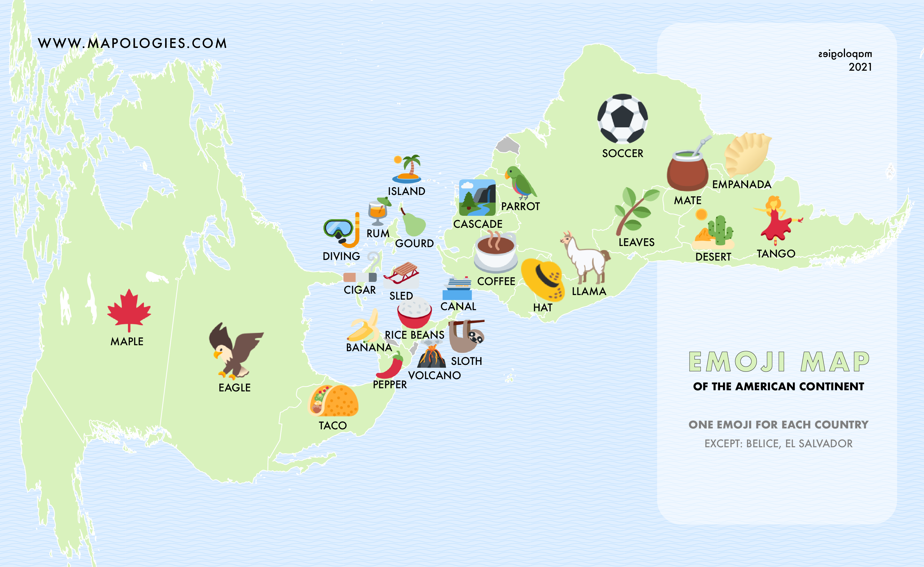
Mapologies is a website that shows many interesting etymology maps such as this one showing the word for Earth throughout Europe-from their planets page.

The countries are color coded by the language family origins of the words. Here are peaches from the fruits page.

I like the peach shapes in the legend though they're probably just Apple Computer logos.

Beyond etymology, they've also branched out to other creative items such as the tripoint constellation (where three countries come together)

and emoji maps.


Thursday, April 18, 2024

The Possible Collapse of Oceanic Circulation

This map, via Down to Earth shows the Atlantic Meridional Overturning Circulation (AMOC).

The AMOC is like a "heat conveyor belt". It moderates temperatures on the planet by moving warmer air to northern latitudes while returning cooler air to the tropics. It has already slowed down by about 15%, according to a 2021 study published in Nature Geoscience. This current could come to a halt sometime this century due to global warming. 

The effects of this would be pretty devastating to much of the planet. It would mean more heat in the tropics, possibly drying out the Amazon Basin, more melting of Antarctic ice and limiting monsoons in India and Africa which are relied upon for growing crops. In Europe a collapse would mean a major cooling of average temperatures. We might even see a reverse of the current migration situation where climate refugees begin moving south instead of north. For much more details, see downtoearth.org.


Wednesday, April 10, 2024

Planning for the Next Eclipse

Maybe you saw Monday's eclipse and were impressed enough to want to travel to see another one or maybe you missed it because life got in the way or you couldn't justify the time and expense of travel. Or, maybe you're like me and foolishly traveled to Rochester, New York where clouds like to gather and linger. Here is what I saw in the zone of totality,

a solid wall of clouds. Even so, the experience was worth it, watching the sky get completely dark in the middle of the day and suddenly get light again. So where will the next ones happen? Unfortunately not in the continental United States for another 20 years. However, if you want to travel or plan way ahead here are some maps for you.

From the Great American Eclipse page here are the eclipses between 2021 and 2030. From that same site you can buy the Atlas of Solar Eclipses 2020 to 2045. This book shows details for 56 eclipses woldwide with maps of each path. The cover is striking.

While on the subject of atlases, the cover of the Atlas of Central Solar Eclipses in the USA shows eclipses out to 2099, if you plan on living that long.

At a recent talk at the University of California, Berkeley Library this map was shown. I would love to se a more readable version. 

A recent article in Time shows somewhat detailed paths for eclipses up to 2067. They're just Google map screen shots with lines so you will need a more detailed map for trip planning. Here is an example of the 2034 eclipse that will traverse Africa and parts of Asia.
Finally, if you really want a deep dive EclipseWise is your source for details of every future and past eclipse, everywhere. Here is their map of the 2021-2030 decade.


Wednesday, April 3, 2024

If Mars Were on Earth

This image of the surface of Mars was released last Spring as part of the Atlas of Mars. Images were compiled from the Emirates Mars Mission "Hope", an approximately two year mission in that began orbiting the planet in 2021.

via New York Times
 Some remarkably detailed images and maps have been created, including this one showing topography.

via New York Times

A zoom in on this shows that there are lines of latitude and longitude.

From the above image you can see that Olympus Mons, the highest point on Mars is located at around 18 degrees north. This got me thinking about where these features would be placed on Earth so I projected the map.

The first version of this map was better but my computer mangled it. This recovered image is a bit warped but you get the general idea. The large volcanic mountains hover in the Pacific Ocean off the coast of Mexico. The other most prominent feature, the Hellas Planitia, a giant impact crater would be just north of Antarctica. 

Keep in mind the longitude is an artificial construct. Latitude is based on a planet's center of rotation but longitude starts where a society chooses it to start. On Earth, a bias towards England has won the day. On Mars someone made a decision about the center of longitude (I have not been able to find out how that was determined yet) and there it is. In other words Olympus Mons could be anywhere on the 18 degree north latitude. Puebla, south of Mexico City, near San Juan, Puerto Rico, in the Sahara Desert or southern India.

I tried a similar and maybe more successful approach with the first image here. I could not find what projection was used so I just projected it onto a world map with a Mollweide projection, which seems close to what was used.

I manipulated the image after the fact to make the countries white instead of black. This created an unintentional yarn-like effect that I really like,

reminding me of this 30 Day Map Challenge Map I made in 2022.

This projection had the effect of moving all the features closer together so that the big volcanoes are further east, closer to the coast of Mexico, 

while the Hellas Planitia is further west, closer to Madagascar.

Useless exercise? Maybe, but it was fun to work on and somewhat informative.