Wednesday, August 7, 2024

Summer Light Reading 2024

Here is another installment of what is becoming an annual summer tradition. Just like the light beach reading, here is some light map reading. Not much to comment about, just some maps and related items I like.

First of all since the Olympics are in Paris, a nice papercut map you can enjoy, or buy here.

A very colorful map from Wikimedia Commons showing the different sections of the Rhine River. As one reader pointed out it looks like a water quality map and probably is as river quality tends to get worse as more cities and farms downstream dump pollution into them.

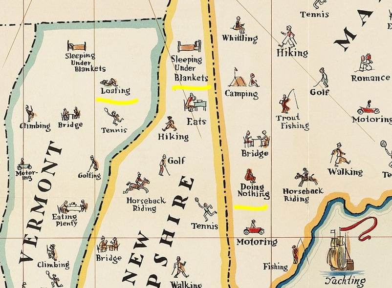
A map of things to do in New England. I copied a portion and highlighted some of my favorites such as "loafing", "sleeping under blankets" and "doing nothing".

Transit map of Kaohsiung on Taiwan. There are some great station names like Dream Mall, World Games and Oil Refinery Elementary School.

A screen shot from Yahoo Japan that I like for no specific reason.

Finally, Tsunami Generating Earthquakes. I think this originally came from some social media site that was once known as Twitter. Maybe from the U.S. Geological Survey.

OK, back to your beach read.

Wednesday, July 31, 2024

More Maps and Views at the British Library

Here is another installment of maps on display at the British Library - part 1 can be found here.

Estate Map by Margaret Bowles, 1659

Apologies for the dark and shadowy picture, the display hall is not brightly lit. Margaret Bowles was an English cartographer whose surviving maps are rare. Her husband and a team of surveyors took measurements of this estate and she transformed the data at reduced scale to make this map. It was made for the estate's managers and is one of the earliest depictions of an English rural landscape.

Mapping Mountains in Wales, 1838

From the library's description: "In the 1830s, Britain’s Ordnance Survey sent surveyors to Northwest Wales to verify data that had been gathered two decades earlier. This is one of the resultant hand-drawn maps, showing the mountainous region of Snowdonia. Its author Thomas Budgen (active 1822-1856) used various drawing techniques to illustrate relief, including close parallel lines known as hill-shading and sketched details of rock formations. At the same time, other surveyors were beginning to experiment with contouring, the relief depiction that is widely used today. Information from this map was incorporated into an engraved map published in the Tower of London from 1838." 

My phone picture is not very high resolution but here is a close up to show Budgen's style of relief depiction.

Gilbert and Ellice Islands Separation Stamp
 

In 1976 the Gilbert and Ellice Islands, a British colony in the Pacific Ocean were separated and eventually became the independent nations of Kiribati and Tuvalu. There is a large image of this map-centric commemorative stamp hanging in this exhibit and also,

a separation of the separation stamp! Here you can see the text separation layer of the artwork displayed on top of the rest of the stamp.


Wednesday, July 24, 2024

Paris Olympics 1924

Paris will host the Olympics in a few days. They previously hosted them 100 years ago. Here is a small map of the 1924 Olympic venues. 

via metropolitiques

Artist Pauline de Langre has some nice, artistic maps showing the venues in 1924 and 2024.

A bit hard to read at this scale but you can click above or here to see it better.

Here are screen shots of the central area for 1924 and 2024 respectively to compare them more easily.

1924

 
2024
It is easy to confuse the Stade de Paris (now Stade Bauer) and the Stade de France. Their locations are nearby but Stade de France is where many 2024 events including the closing ceremonies will be held. Most of the venues are different but the main 1924 stadium (Stade du Colombes, renamed Stade Yves-du-Manior) will still be used for Field Hockey. The famous Roland Garros tennis complex was built a few years after the 1924 Olympics and was used in World War II as a detention center for "undesirables", people whose big sin was being from the wrong countries or having Communist leanings.

These maps and other maps and drawing can be browsed in more detail here.


Wednesday, July 17, 2024

The Whataburger Power Outage Map

When Hurricane Beryl struck Texas last week it left nearly 2 million Houston area residents and businesses without power. Local power company Center Point Energy's online power outage map has been unavailable since May. Social media user BBQBryan noted that Texas based Whataburger's app could be used as a de-facto power outage tracker.

The orange W's indicate an open location while a gray W means closed. Whataburger is open 24 hours so gray means a likely power outage. Here is a more complete area map from July 9th via KERA. 

I'm a little late to the game here so when I checked their web site a week later (I don't have the app because I live in a Whataburger desert) the Houston area looked completely open.


Wednesday, July 10, 2024

Maps and Views at the British Library

The British Library contains over 4.5 million maps, atlases, globes, and digital models dating back to medieval times. A small sample of these are displayed on the walls in a section called "Maps & Views". Here are some mediocre pictures I took with links (where I can find them) to online resources. As the British were the ultimate colonizers, here are a few maps from their colonial empire.

Plan for a New Capital, Punjab - when Pakistan was split off from India, the state of Punjab was divided between the two with the capital, Lahore on the Pakistan side. India needed a new state capital for East Punjab and the Prime Minister Nehru hired Le Corbusier to design it in a grid pattern. He conceived the Chandigarh Master Plan as analogous to human body, with a clearly defined head (the Capitol Complex), heart (the City Centre), lungs (the leisure valley, and open spaces), the intellect (cultural and educational institutions), circulatory system (roads), etc. More details about this map can be found on this page from Planning Tank.

Gertrude Bell's Military Intelligence Map - Gertrude Bell was an English writer, administrator and  archaeologist who spent much of her life exploring the Middle East. She was influential in the founding of Iraq. She was summoned to the area during World War I and recorded the positions of features on the land using surveying equipment. Red diagonal lines show her path of travel, while details from subsequent travelers were added later. You can read more about her life and maps in this Library of Congress blog post.

Map of the county of Dinghai in the Island of Zhoushan -  Zhoushan is an island south of Shanghai that the British captured and lost few times during the Opium Wars and attempted to colonize as a major trading port. The walled area is the city of Dinghai. There is no credit that I can find for the map's author but the rendering of mountains is truly unique. Some of them look like jumping dolphins. I have not found this exact map online but there is a similar version at the Reading Digital Atlas.


Wednesday, July 3, 2024

An Appreciation of Ordnance Survey Maps

I spent some time in May at the British Library randomly looking at atlases and maps, some of which will be featured here in upcoming weeks. They have a huge collection of Ordnance Survey atlas books of 1:1056 scale (1 inch = 88 feet) map sheets. While these maps are primarily black lines on white paper, their beauty lies in the remarkable detail.

Note: these maps are in great shape, with fairly pristine white paper. My phone has a tendency to darken maps when I photograph them. I could have brought back the actual color by adjusting the brightness and contrast but I kind of like the old-timey sepia look of these images.

Here are the gas tanks at Kennington.

Here is some nice detail of the railroad infrastructure at the Nine Elms Works, near the Battersea Power Station.


 The only color I saw in any of these is in the water bodies.

One of my favorite places is the Greenwich Observatory, right on the Prime Meridian.

Finally, a little more detail in Greenwich Park showing the Queen's Oak and Bower and the old Magnetic Observatory.


Wednesday, June 26, 2024

Snickelways of York

Note: In May, I spent some time traveling through England. This is the first of maybe several posts from that trip.

In York, England a snickelway is a narrow passageway variously referred to as a"snicket", "gimmel" or "alleyway", the word being a combination of all of these. Mark Jones mapped the snickelways and wrote a guide book to them.

I took this photo as an example of a snickelway.

His book only includes the ones on the north side of the river Ouse. He created a path where you do not repeat your steps. This map nicely illustrates the circuitous route you need to follow to accomplish this.

This route takes a few hours to complete and if you're in York you will likely find other things you want to do. I covered almost the entire route because I am obsessed with these things. The route begins and ends at Bootham Bar, one of the city gates near the Minster, York's impressively large cathedral.

The middle area is where the most action is with a whole bunch of sneaky passageways and the Shambles (a medieval street whose buildings look like they could tumble over at any time).

Also in this area is Victor J's Bar, featuring their own "snicketway" map on the wall.

Jones fills the book with commentary,


very detailed instructions, various other current and historic facts about York and even advice for navigating "shopsnickets", passageways that require walking through stores and behaving as any normal prospective customer.