As a follow up to Women's Suffrage in 1908, here is an ad from 1917 showing how suffrage (the white areas*) had expanded through most of Canada and parts of the United States.
Wednesday, March 30, 2022
Wednesday, March 23, 2022
The Atlas of Imagined Places
The Atlas of Imagined Places by Matt Brown is now available.
The book shows the "likely geography" of places in literature, media, myths and video games."The authors have taken years to research the likely geography of thousands of popular culture locations that have become almost real to us. Sometimes these are easy to work out but other times a bit of detective work is needed and the authors have been those detectives. By looking at the maps, you’ll find that the revolution at Animal Farm happened next to Winnie the Pooh’s home."
Here is another image from the Amazon page.
Wednesday, March 16, 2022
Emma Hart Willard's Atlas
Emma Hart Willard was a pioneer of education and geography. She saw geography as a foundation for teaching. Her approach was to have students start with maps of their local environment, instead of at a harder to grasp global scale. She published Willard's History of the United States, which included an atlas. Unlike many other atlases, this one began with the indigenous settlement of North America.
The next map, the First Map of 1578 shows intersecting tracks of the European explorers and in pink Sir Humphrey Gilbert's patent, the first land patent granted by Queen Elizabeth I.
The "Second Map of 1620" has a similar look but the ships are for commerce, not exploration, including a Dutch ship "with negroes from Africa". The entire east coast up through New Brunswick is labeled as the North and South Colonies of Virginia and there is an inset map of the places at the mouth of the Hudson River visited by the Dutch. The rolling up of the left corner of the map is a nice touch that she employs frequently.
The next group of maps show various wars with the indigenous tribes and between the British and French and then the gradual formation of colonies, followed by some Revolutionary War maps. It concludes with a map of the "Principal Seats of War 1812-13-14" showing the areas around Detroit, Buffalo, New Orleans, the Chesapeake Bay and St. Lawrence River.
You can read more about Willard's life and work on the Worlds Revealed blog from the Library of Congress. The atlas can be seen here.
Tuesday, March 8, 2022
Women's Suffrage in 1908
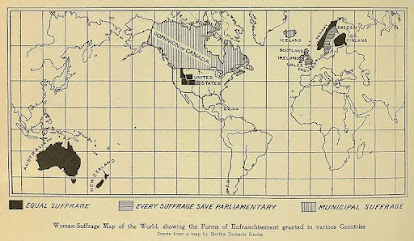
This map shows the international state of women's suffrage in 1908. It was originally published in Harper's Magazine and reprinted at ThoughtCo.
Full equal suffrage existed only in Australia, New Zealand, Norway, Finland and a handful of poorly drawn northwestern U.S. states. Finland also allowed women to run for Parliament. The "Municipal Suffrage" of Canada and Iceland meant women could only vote in local elections. The U.K. and Sweden vote in non-parliamentary elections.
This Wikipedia page gives more details. The page also mentions Latvia though not shown on the map. In many cases the right to vote was restricted for a time to married or property owning women. In Australia indigenous women were excluded from voting. It looks like Kansas is shaded in light gray though the Wikipedia page has that state granting women the right in 1912. Maybe it was being considered at the time. There was a gradual trickle of states between 1908 and 1920 when finally women were allowed to vote nationwide in the USA by the Nineteenth Amendment.
Wednesday, March 2, 2022
The War for Ukraine in Maps
I haven't thoroughly researched all media outlets but the maps from the Financial Times depicting the situation in Ukraine are the best I have seen. Click below to see a more readable version.
They are very subtle but effective without showing a large number of intersecting arrows or distracting explosion symbols. Here is their close up of the Kyiv region.Finally, here is an elegant flow map showing the numbers of refugees and where they have been heading.
If you scroll down the page you can see maps from the last several days. It is interesting how little they have changed in the last few days despite all the carnage.
Wednesday, February 23, 2022
Al-Khwārizmī's Geography
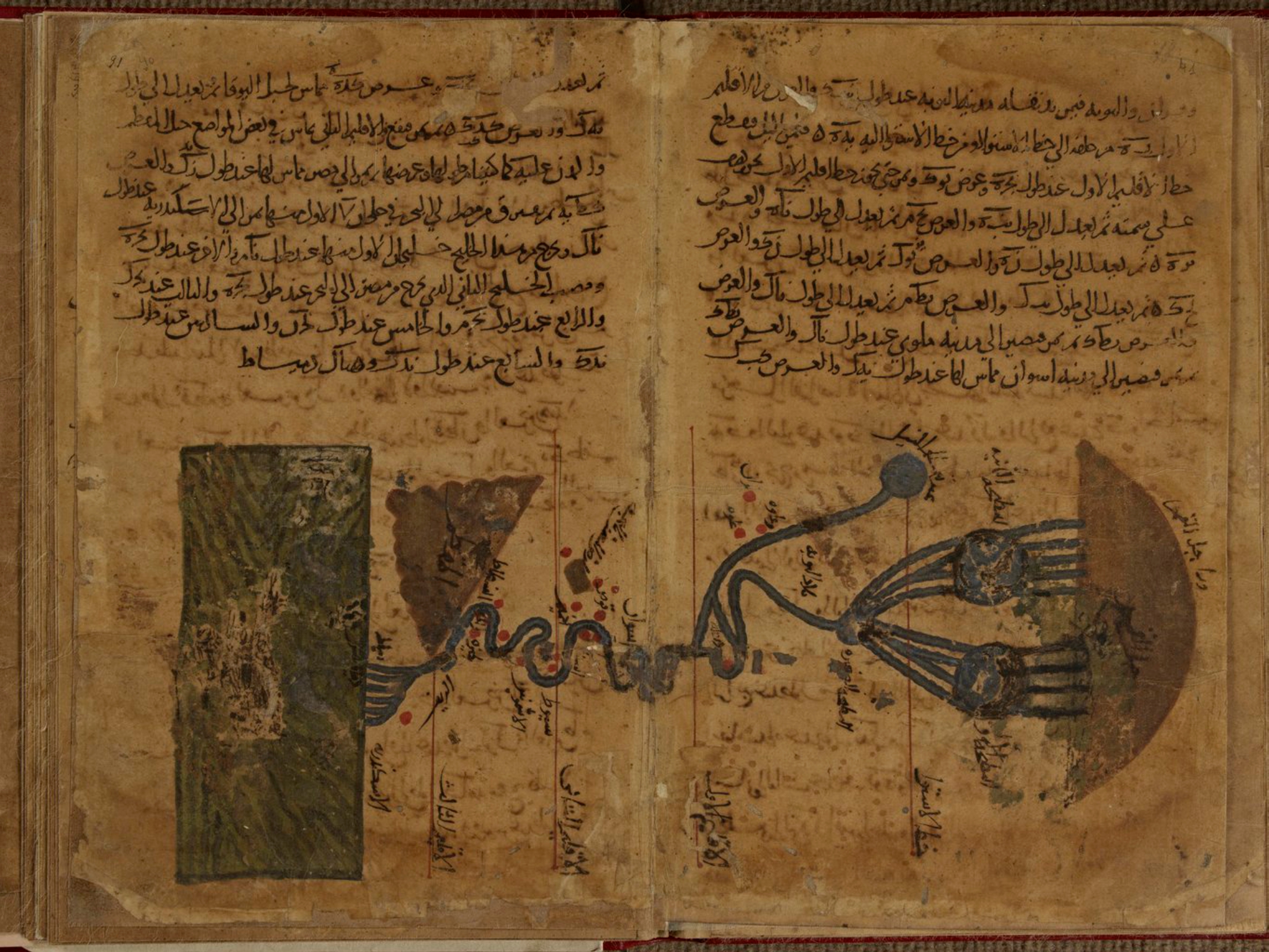
Persian polymath Muḥammad ibn Mūsā al-Khwārizmī (c. 780-c. 850) had a huge influence on the development of algebra, the Hindu-Arabic numeral system, astronomy and cartography. His Kitāb Ṣūrat al-Arḍ (description of the Earth) was a major reworking of Ptolemy's Geography correcting much of his data for The Mediterranean Sea, Africa and Asia. Here is the earliest known map of the Nile River from that work,
some nice details of the origins and branches of the river,
and the delta where it meets the Mediterranean.The only surviving copy of this book is in the Strasbourg University Library in France. The copy is in bad shape and parts are almost illegible. Though latitudes and longitudes of thousands of places appear the world map is missing. Historian Hubert Daunicht reconstructed this map, the only copy I can find is this low resolution version from Wikipedia, showing the Indian Ocean.
For fans of "World Music" a band called Guess What named an album Al-Khawarizmi (with a slight spelling difference). The cover includes an early Islamic world map in the lower corner.
A previous post on this blog has a partial explanation of some of the elements of this map.Wednesday, February 9, 2022
African American Homesteaders
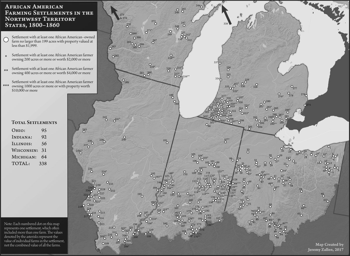
Homesteaders are widely thought of as white, but as this map shows there were a large number of black homesteads in the "northwest territories" in the early 1800s.
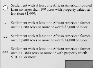
The map above is from The Bone and Sinew of the Land by Anna-Lisa Cox (image via Atlas Obscura). There are asterixes denoting the places where more valuable land was owned by African Americans. This is not a very clear way of quantifying data, but you can see it in the detail from southwestern Michigan.Here is the legend.
What the map does clearly show are some interesting clusters of settlements in Michigan, Ohio and Indiana. By the late 1800's increasingly restrictive laws and resentment among nearby white settlers had driven many of these settlers away. Cox's book brings to light these forgotten settlements.
A similar map appears in Free Black Communities and the Underground Railroad: The Geography of Resistance by Cheryl Janifer LaRoche. You can see it in the "Look Inside" feature on the Amazon link above. The cover is also adorned with some nice mappy details.