Wednesday, October 26, 2022

Middle Constellation

Middle Constellation is a schematic imagining by Jug Cerović of China's cities as a constellation of stars. It is available as a book, both in hard copy and ebook format. The book shows you how to draw the constellation in "8 simple movements".

The constellation is centered on Wuhan, a city infamous for pandemic reasons but also central to the populous east of China.


Draw lines between Beijing in the north and Shenzhen (the center of an urban agglomeration that includes Hong Kong and Guangzhou) in the south, and then between Chengdu in the west and Shanghai in the east. These lines will intersect at Wuhan. The beginning animation at top shows the geographic distortions that need to be made for schematic purposes.

Eventually more cities and connecting lines are added and the drawing is finished with a nice simplified curvy coastline.

Here is a picture of how it looks in hard copy.
While available for sale Cerović also generously allows you to the whole thing in pdf format on the project page.


Wednesday, October 19, 2022

Global Happiness Report 2022

 Visual Capitalist has been mapping the World Happiness Report for the past few years.

The World Happiness Report is "powered by Gallup World Poll data". It is based on a combination of economic factors (such as GDP), social factors such as freedom, social support, and perceptions of corruption as well as life expectancy. In the last few years it also also included the effects of COVID-19.

Finland has consistently led the world for the last few years. Other northern European countries are also high up on the list. Ukraine is unsurprisingly the least happy country in Europe but still happier than most of Africa.

Surprisingly, the United States is doing well, despite the horror show that's portrayed in campaign commercials. Unsurprisingly, Afghanistan is lowest. Bhutan, where happiness is part of government policy, does not appear to have participated. The overall rates of happiness have increased slightly over the last few years. Here is the 2019 map for comparison.

Unfortunately, they changed the color scheme a bit this year making the comparison a little tougher.The bright pinks and purples while more distinct are a little hard on the eyes and make me a little less happy. Anyway I created a comparison animation for your enjoyment.


Wednesday, October 12, 2022

National Real Estate Boards Map

 In 1926 the National Association of Real Estate Boards (NAREB, now National Association of Realtors) held their annual convention in Tulsa, Oklahoma. This map was used to promote the event showing how "all roads lead to Tulsa".

via Leventhal Map Center

The map shows a happy, prosperous and mostly white nation welcoming growth in places with "plenty of room" like South Dakota.

Just five years before Tulsans had taken place in one of the worst racial massacres in history but that is completely brushed aside here in favor of showcasing a booming, modern city. The bright yellow text box at the bottom tells you that "you will find Tulsa and all the Oklahoma boys ready with the Old West-Indians, cowboys, bronchos-all brushed up pretty to show you the time of your life. And the New West with its oil wells and up to the minute skyscrapers will give you something to think about."

South Florida was one of the booming areas highlighted on this map with Miami and Tampa shown literally exploding.

The detail above shows two "binder boys" being kicked out of Florida. Binder boys were real estate speculators, house flippers in today's parlance, who would buy houses and quickly resell them for much more money, before their payments were even due. While this kind of practice was common in the real estate the problem wasn't what they did but "how they did it: without professionalism." More about the binder boys and the map as a whole can be found on this page from the Leventhal Center.

Silly rabbit, land is for people!


Thursday, October 6, 2022

A Collection of Raymond Chandler Maps

I'm not really a fan of detective novels so all I previously knew about Raymond Chandler is from the Robyn Hitchcock song "Raymond Chandler Evening". The pavements are all wet, there's a body on the rails, he's not the reassuring type, etc. I've since learned that his work is so geographically detailed that it has inspired at least three maps of Los Angeles.

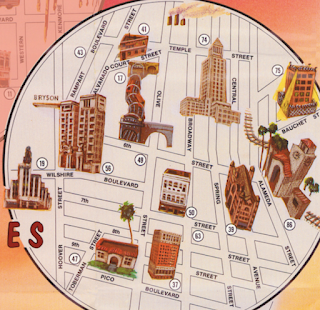
The above map, titled "Shamus Town" refers to the author's use of "Shamus" to mean cop or sometimes detective. This seems to be just a pictorial map from that era with a different title block. Originally drawn by Karl M. Leuschner, it was published in 1932 by Metropolitan Surveys of Los Angeles. Then modified to be a "Raymond Chandler Mystery Map" in 2014 by Loren Latker who runs the Shamus Town web site dedicated to Chandler. I have not found anything different other than the title. The original can be seen here via LA Magazine. The original can be seen here via LA Magazine. Here is the title block.

The second map is from Aaron Blake Publishers, 1985-1987.

It features blow-up circles for areas covered in the novels: Downtown, Hollywood, Santa Monica (sometimes aliased as Bay City), Lake Arrowhead and Mexico. 

There is a number key on the right listing locations by book. Some addresses are in italics suggesting his desire to disguise locations. These are listed after the actual locations. The map is "thoroughly researched" but "some places no longer exist, others never existed ... the exact placement of still others remains debatable."
These bubbles allow the size of important areas to be enlarged but even within the bubbles there are major distortions like placing Malibu immediately next to Santa Monica on a straight coastline. I like the electric look of the Beverly Hills area that connects the Hollywood and Santa Monica bubbles. The Shamus Town site has a nice feature where you can click on a section of the map and get both a blow-up of that area and the relevant text from the sidebar.
 
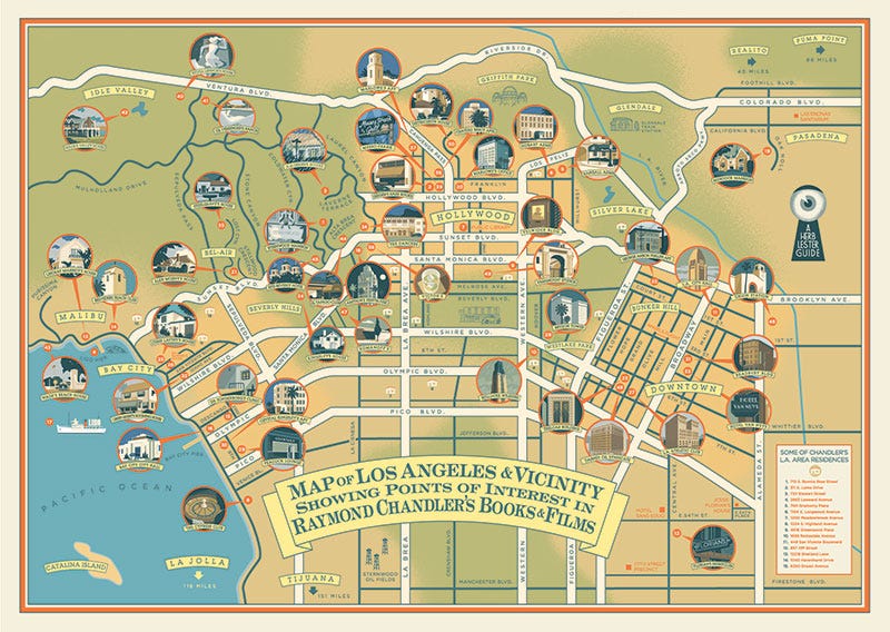
More recently historian Kim Cooper collaborated with Herb Lester Associates in the U.K. to create this "guide to Chandler's world and that of his noble alter-ego, the private detective Philip Marlowe. It mixes locations from the books, the films and Chandler’s personal life. There’s the crummy dive where Moose Malloy went looking for Velma (Farewell, My Lovely); the actual lounge where Marlowe and Terry Lennox ordered gimlets (The Long Goodbye); the top-floor suite where oil executive Chandler got his priceless education in how a dirty, sun-drenched city really operated. It’s an insider's guide to the city Chandler knew, and can still be visited today."

It can be purchased here and more details about the map are available on Electric Lit. Here is a not much higher resolution detail via heflinreps.

Thursday, September 29, 2022

Cider Donut Map

Alex the Cider Donut Reviewer has put together a map showing where to get cider donuts in New England. 

While not getting high marks for creativity, the map is impressive in its reach. Otherwise it's just another teardrop filled Google Map with the "Satellite View" (the detailed images are from airplanes) defaulted-not as easy to read as the map view IMHO. Blue represents where you can get them "fresh and hot" while purple are the pre-made ones. A click brings up the Google detailed info panel with links to reviews and their web sites.

Explore more here.

Wednesday, September 21, 2022

Bird Migration Explorer

Audubon's Bird Migration Explorer is a guide to "the heroic annual journeys made by over 450 bird species, and the challenges they face along the way."

The legend in the upper right corner shows what the colors mean but also allows you to filter which types of birds you are interested in.

Hovering over a track, you can isolate the species,

then with a click bring up statistics, stories and species-specific maps. The speaker button lets you listen to the birds.

Here is the species connection map for Ospreys showing summer (green), winter (blue) and year-round ranges in yellow.

There is a red "take action" option that will add you to their mailing list to get updates on how you can help these birds.

The search for a species function has nice pictures of each species to scroll through,

though when I started typing Osprey I ended up with a Bell's Sparrow instead. Must be the network issues we've been having.

Explore on your own here

Wednesday, September 14, 2022

King Charles III-Urban Planner

Britain's new King has a strong interest in urban planning. In fact he helped design a "new urbanist" town, Poundbury, just outside of Dorchester in Dorset. Here is a photo, via Flickr, of an in situ map of the town as it was in 2008. Click for better readability.

from Flickr user Anne

The town's traditional architecture gives it an (artificial) old-time feel while embracing principles of sustainability such as use of local materials, renewable energy sources like biomethane, and energy efficient designs.

Image via Duchy of Cornwall

A 2016 article in the Guardian begins with this quote: "Poundbury, the Prince of Wales’s traditionalist village in Dorset, has long been mocked as a feudal Disneyland. But a growing and diverse community suggests it’s getting a lot of things right."


This image from planner Léon Krier shows how much of the plan had been completed (in black) as of 2013.

via Architect Magazine

Here is a somewhat dulled image of the master plan showing land uses.

via DorsetRoads

The streets are designed to slow traffic and the walkability index is high according to Space Syntax,

however "the progressive attitude to cars hasn’t curbed habits: a survey conducted at the end of the first phase showed that car use was higher in Poundbury than in the surrounding rural district of West Dorset. The free-for-all parking policy, meanwhile, has turned many of the streets and squares into a car park for Dorchester shoppers." - Guardian, 2016

The town is scheduled to be completed in 2025 and a look at Google Maps suggests it is getting close.