Wednesday, July 30, 2014

Energy Maps For Your Wall

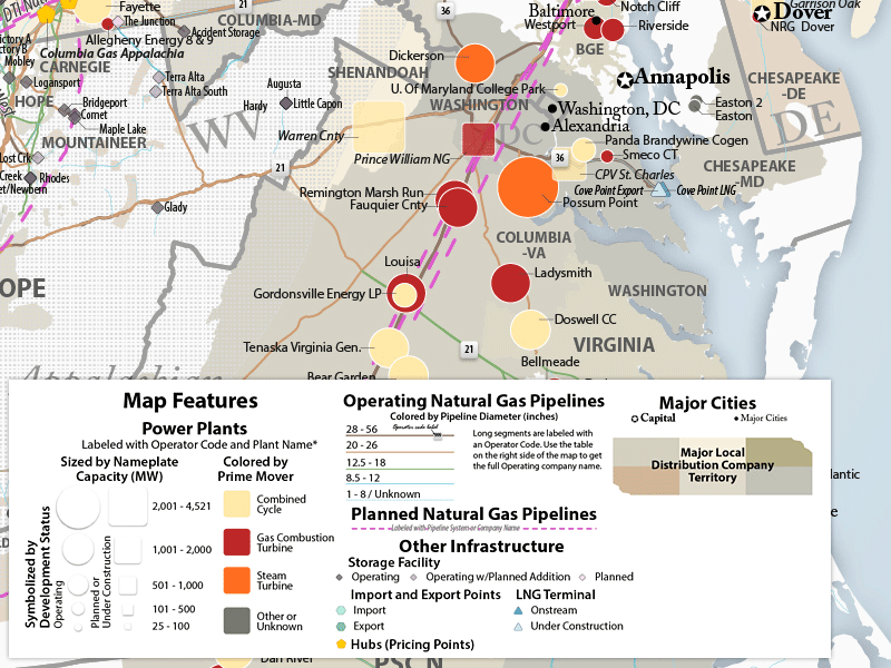
Say what you want about the fracking frackers but they do make pretty maps. Platts "consistently sets the industry standard for visualizing the supply, generation, distribution and transportation of natural gas." I'm not sure who the competition is in the supply and distribution visualization field, but Platts does a nice job with their colors, subtle shadings and National Geographic-like fonts. They also use shapes to somewhat effectively distinguish between operating and proposed power plants. Here is an example from the North American Natural Gas System Map.  


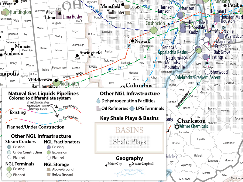
These are available as wall maps and/or on CD-ROM. The pricing is a bit steep but if you're an energy company executive $500-$800 for a wall map is no big deal. Here is another example from the North American Natural Gas Liquids Map.

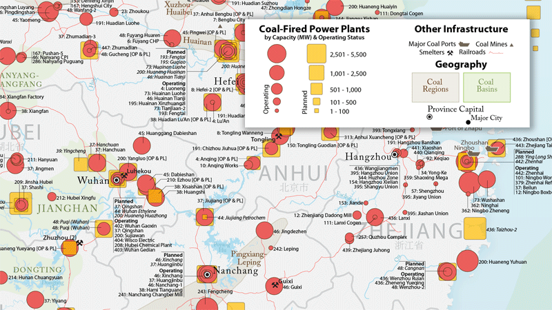
For an International perspective, here is the China Coal Power Generation Map. No wonder the air quality in much of China is so bad.

Wednesday, July 23, 2014

The Negro Motorist Green Book

Fifty years ago, I was born the Civil Rights Act was passed. The Negro Motorist Green Book provides a good example of how difficult travel was for African-Americans before passage of the Act. Published in the 1930s-1960s, this book listed places where travelers could shop, stay, eat and get gas without being refused service, or suffering a much worse fate. A copy of the 1949 edition can be found here

The book lists accommodations by type for the United States as well as Canada, Mexico and Bermuda. Here is a sample page.
Unfortunately there are no maps. I was curious about what this would look like on a map so I decided to pick a city and map the addresses. I chose Memphis for several reasons. It's a good size (not too many points, but enough to make it interesting) and it's a place I'm entirely unfamiliar with so I would not have any preconceived expectation of what the map would show. One final random reason is that I had flipped to the Tennessee page when thinking about this project. Click the map below for better legibility.
I used a well-known mapping service to locate the addresses and ArcGIS Online for the background maps. A few assumptions on street names were needed. Landerdale and Lauderdale were assumed to be the same street as were Beale St and Beale Ave*. Unsurprisingly there is a clear cluster one side (south) of town, while almost nothing on the other side. Here is a detailed map of the south side cluster.
Most of the businesses were located near the Beale Street music district, almost certainly not a coincidence. Of course, the landscape is very different today. Most of these businesses are gone, the street pattern has been altered and there was no FedEx Forum (or FedEx, Memphis Grizzlies, or Disney on Ice) in 1949. Here is a blueprint map I was able to dig up from 1949. 
The passage of the Civil Rights Act has made the Green Book obsolete so fortunately for travelers today my map is just a historical curiosity, not a necessary guide.

* This assumption appears to be correct based on the blueprint map.

Wednesday, July 16, 2014

40 Maps That Won't Explain Anything-Part 4

This is the final (for now) installment of this series. However, there are so many of the "40 Maps That Will Increase Your Earnings and Change Your Life" pages out there now that I might be compelled to put out some bonus editions of these in the future.

It was pointed out to me that some of the maps in Part 3 actually explained things. I will try to fix that situation with less meaningful maps this time.

31. The Provinces of Bolivia
32. Darts being thrown at random provinces in Cambodia to illustrate PowerPoint Maps Online

33. Detail from the Austin Music Map - love that purple river!
http://austinmusicmap.com/
34. The Interstate 11 Corridor proposed to connect Phoenix and Las Vegas.
http://www.washingtonpost.com/blogs/govbeat/wp/2014/02/25/nevada-governor-wants-to-make-new-interstate-a-presidential-priority/
35. Psychedelic precipitation map of Hawaii. With a bonus Maui blowup.
36. Hawaii refrigerator magnet from Shop in Paradise.
http://wwww.siphawaii.com/Prodimages/Magnet_Map_Hawaii_old_large_SIPhawaii.jpg
37. The High Sierra region from Visit California - I like their maps and we just visited this region.
38. World placemat for "bigger kids"  from the Reader's Catalog. Got cliches?
http://cdn.shopify.com/s/files/1/0067/8732/products/Placemat_World_1024x1024.jpg
Here's the Western Hemisphere zoomed in. Note the atrocious placement of New York City. Guess where this company is located? If their 646 area code is any indication they're based in New York City!
39. Speaking of New York City - here are the Trees of Prospect Park. On the Prospect Park page you can  click on a tree to get details and pictures, but then it would be a map that explains something so be careful!
40. Time to put this series to sleep with some White Comic Map bedding from Debenhams. If you zoom in on the image you'll see that the "map" is a series of comic book images.
http://int.debenhams.com/us/product/white--comic-map--bedding-set/306907936480/

Wednesday, July 9, 2014

Tour de France Maps

A few days ago the Tour de France began in England. To honor the English "Grand Depart" cupajoe, a user on visual.ly designed this London Underground style tour map.
http://visual.ly/tour-de-france-map-2014-underground-style
In truly British style, it shows the English Channel as a mere river to cross and does not delineate boundaries with Belgium or Spain, two countries that also share part of the route. The color scheme is not very useful, except to help translate the legend. However, this kind of map should not need a legend. It's much easier to have the dates right on the map and the starts and finishes of each stage clearly defined. The map below (from Cycling Weekly) does a better job in all respects and shows true geography. It's also more readable and much more attractive.  
http://s3-eu-west-1.amazonaws.com/inspire-ipcmedia-com/inspirewp/live/wp-content/uploads/sites/2/2013/10/Tour_de_France_map_2014_full.jpg
There must be a higher resolution version of this map but I have been unable to find it. It would be nice to be able to read the Légende and the tiny credits on the lower left of the map.
Update - Thanks to an anonymous commenter, we now have link to a higher resolution version of this map.

This map also makes for a nice mug.


Thursday, July 3, 2014

Fireworks Laws Across the USA

Hurricane Arthur may screw up plans our 4th of July plans here in the northeast. If not then our "nanny state" regulations will. We know all the neighborhood kids like to check out the laws before setting off fireworks so here they are state by state via the Washington Post
http://www.washingtonpost.com/blogs/govbeat/files/2014/07/StateFireworkLawsSummary.gif
I get that they are trying a fireworks color scheme but did they really have to make the "only novelty fireworks" category such an indistinct color? Since this is only one state (Arizona) why not give it a unique (novelty) color so you can tell it apart from the other states? I would also make the white states a different color because it looks like no data at first glance. Since they didn't consult me, this is what you get.

Tuesday, July 1, 2014

Canada Day

In honor of Canada Day, here are some maps from Macleans magazine's Mapping Canada series. Not all of these maps are useful but this one showing cities paired with other cities on the same latitude is interesting.
http://www.macleans.ca/society/mapped-canadian-latitudes-around-the-world/
EarthTools was used to find the latitude pairs. Interesting how different the climate is between Edmonton and Dublin, also for several other latitude pairs.

Job growth and shrinkage - mostly growth except for a few scattered cities in Ontario and Quebec.
http://www.macleans.ca/economy/economicanalysis/mapped-five-years-of-canadian-job-growth/
Finally, the familiar cliche map. Whereas these kind of maps are often full of nastiness, this one is mostly polite in an appropriately Canadian way.
http://www.macleans.ca/society/mapped-o-canada-our-home-and-cliche-land/

The entire series can be seen here.