
An ongoing series of articles in National Geographic detail Paul Salopek's walk to trace the spread of humans throughout the world. In the most recent installment, he walks across the Hejaz of western Saudi Arabia, visiting ancient wells - the blue symbols on the map.
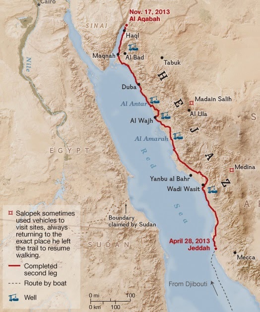 These wells were located a days walk away so that travelers would be able to traverse the desert region. Knowing the location of the wells was a matter of life and death.
And now for something completely different - a ridiculous comparison!
Today's electric car pioneers face a similar difficulty. Routes must be carefully planned around the location of charging stations. A recent article in the Mercury News details the first cross country trip in a Tesla by John Glenney. The article includes this map of their charging stations.
 Tesla has a network of charging stations located close enough (about 265 miles per charge) to be able to travel certain routes across the USA. During Glenney's trip the Hagerstown, Maryland facility was not ready. He had a stressful trip from Newark, Delaware to Somerset in western Pennsylvania, arriving with only 11 miles left on his charge.
As the Tesla network expands, trip planning will gradually become less important as it has in Saudi Arabia, where drivers can find bottled water at gas stations. The wells now sit abandoned as traffic rushes past and planes fly overhead.
And now for something completely different - a ridiculous comparison!
Today's electric car pioneers face a similar difficulty. Routes must be carefully planned around the location of charging stations. A recent article in the Mercury News details the first cross country trip in a Tesla by John Glenney. The article includes this map of their charging stations.
As the Tesla network expands, trip planning will gradually become less important as it has in Saudi Arabia, where drivers can find bottled water at gas stations. The wells now sit abandoned as traffic rushes past and planes fly overhead.


No comments:
Post a Comment