
This map, circa1888 is a remarkable exercise in California boosterism.
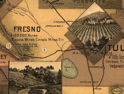
 Details include a list of crops or products from each county, pictures of farms, scenery and cultural attractions, railroads and topography. Cities are notably not emphasized.
 A nice touch at the top - the Sierra peaks.
 Also - "Big Trees"
 There are additional maps showing average temperatures and soils. The soils map is full of cheery optimism about agricultural productivity - "some of this territory is doubtless arid lands. But portions of it once considered irreclaimable are now yielding enormous crops."
I especially like the bit in the lower left corner that shows how many other states can fit into California...
 ...because it reminds me of that SCTV skit mocking 1970's Soviet propaganda. Diabolical laughter ensues as more countries are fit into Russia.
 Argentina - "it looks like tiny sausage against a vast, colossal size of Mother Russia!"
BONUS VIDEO! (If the embedded video below disappears then click the picture above for video)
Note the geographical inaccuracy as he places Australia over Kazakhstan and refers to it as "Ukraine."

I especially like the bit in the lower left corner that shows how many other states can fit into California...

BONUS VIDEO! (If the embedded video below disappears then click the picture above for video)
Note the geographical inaccuracy as he places Australia over Kazakhstan and refers to it as "Ukraine."


1 comment:
Love the "What fits into Russia" reference!
Post a Comment