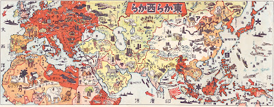
In 1942 this map was published in Japan for children so they could follow the progress of the imperial forces during World War II.
Japan, occupied and allied countries are shown in bright red. The map is full of caricatures of the natural resources of each area. Bold red arrows show the hoped direction of conquest.
Here are some details from northern Africa and southern Europe.
The map, titled "From the East, from the West" was produced at the high point of Japan's war effort for a children's publication.
-via History Today - where you can see the entire map.
Japan, occupied and allied countries are shown in bright red. The map is full of caricatures of the natural resources of each area. Bold red arrows show the hoped direction of conquest.
Here are some details from northern Africa and southern Europe.
-via History Today - where you can see the entire map.


No comments:
Post a Comment