Tuesday, February 27, 2018

Drifters on the Ocean

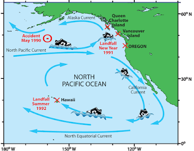
In May, 1990 a storm off the coast of Alaska knocked containers off a ship that was on its way from Korea to the United States. Some of the containers broke open sending 61,000 Nike shoes on a journey through the North Pacific Ocean. The following winter hundreds of Nikes washed up on the shores of British Columbia, Washington and Oregon.
http://www.seos-project.eu/modules/oceancurrents/images/trainers_map.png
To oceanographers these shoes are "drifters," floating objects that enable them to test models of ocean currents. A model known as the Ocean Currents Simulator (OSCURS) predicted that most of these shoes would make landfall in British Columbia about 249 days after the accident. The first ones were found there 220 days after. Later shoes were found off the coast of Oregon showing that the currents diverted some of them to the south. A year and a half later some of them made landfall in Hawaii.

In early 1992, a similar accident sent a bunch of toy ducks into the ocean. Here is a map of "possible journeys" and places they were found over the next 11 years.
http://www.seos-project.eu/modules/oceancurrents/images/ducks_map.png
To reach the Atlantic Ocean they had to pass through the icy Arctic. They have lost their color, according to this article but many are still floating out there.

For more about ocean currents see these pages from the SEOS project.


Tuesday, February 20, 2018

The Changing Geography of Wakanda

Black Panther is a huge Hollywood hit set in the fictional country of Wakanda. The lead character has been through many iterations since his first appearance in Marvel Comics in 1966, as has his country. Wakanda is the most scientifically advanced country in the world. Isolation has enabled it to resist colonization and to develop its own independent technology. 

The first map, from Jungle Action Volume 2 #6, shows the Atlantic Ocean in the lower left placing Wakanda near the west coast of Africa.
https://vignette.wikia.nocookie.net/marveldatabase/images/3/33/Wakanda_from_Official_Handbook_of_the_Marvel_Universe_Vol_1_12.jpg/revision/latest?cb=20160509081608
A couple of episodes later the map was re-presented "with new details." The Atlantic Ocean was removed, probably to place Wakanda more in East Africa. Killmonger's Village is no longer a coastal settlement. There is an arrow in the bottom left of the map pointing to the Indian Ocean. There is speculation that they "flipped" the map (south is now up).
This became the definitive version of the map for decades. In 2008, Marvel published its Atlas of Fantastic Places giving a precise location of Wakanda and neighbors between Ethiopia and Kenya.
https://peterslarson.com/2016/05/14/the-fictional-nation-of-wakanda/
In 2016, a new version of the comic was written by Ta-Nehisi Coates. He drew a couple of new iterations of the map placing it on the western shore of Lake Victoria.
https://www.theatlantic.com/notes/2016/04/the-world-of-wakanda/479466/
The map above was created in Photoshop. Coates discusses his process in this article from The Atlantic. A later, more detailed version was done by Coates and Manny Mederos.
https://vignette.wikia.nocookie.net/marveldatabase/images/c/c5/Wakanda_from_Black_Panther_Vol_6_4_0001.jpg/revision/latest?cb=20160727172642
In the recent movie Captain America: Civil War, Wakanda appears to the northwest of Uganda, close to the location from Marvel's atlas. Here is a screenshot via comicbook.com
http://media.comicbook.com/2018/02/wakanda-1085186.jpeg
The current movie has it slightly to the southwest of the Coates map bordering on Rwanda's Lake Kivu. The image below is from Marvel's Black Panther: The Art of the Movie

Wakanda's location in Africa revealed in art book
Where will it move next?

Wednesday, February 14, 2018

Look North

Going through my recently acquired road maps, I was intrigued by the many different north arrows. Many are gas stations maps-the work contracted out to map publishing companies such as Rand McNally and H.M. Gousha. Oil companies put their names on the map and often their logo on the north arrow.
Here's an example from the Gulf "Richmond Tourgide" - their cutesy misspelling, not mine. Rand McNally produced this map. Here are some more:


Flying A Service Metro D.C. Street Map- Gousha.


Cities Service - I don't know who they were and it was hard to get a clear picture of their logo. This is from their Maine map (Bangor inset). You can see the H. M. G. Co. (Gousha) text.


Before Arco, there was Atlantic - From a Tampa-St Petersburg map-Rand McNally


American - Greater Miami Street Map and Mobil Travel Map of the San Fernando Valley, California - Rand McNally


Two Gousha's - one from the Hertz/American Express Chicago map and one from their own branded New Orleans city map.


AAA's maps used this globe north arrow. They liked to put them in the water.


Here is one from Rand McNally's Los Angeles map. It appears on the LAX airport inset. This map looks very different stylistically from the rest of the map and the Thomas Brothers north arrow explains why.

The other sections of the map all have this dull, understated e.e. cummings- style "n"


Some state tourist agencies.
Maryland - I don't love Maryland's schizophrenic flag, but I like how they incorporated it into their north arrow.


Virginia - very detailed.


Montana-now that's a quality north arrow!


Best of all - South Dakota with its compass ring showing where the needle would point at the center of the state. Two rings, one for true distance and one for magnetic variation, plus the state seal!
 Here are some more


Wednesday, February 7, 2018

More Map Acquisitions

Map Acquistions - Part Two

Central Leningrad from a city guide by Intourist,  travel service of the U.S.S.R, circa 1976.
Another view of Leningrad, Falk plans, Hamburg, Germany, 1976.
A very schematic map of Moscow from Intourist.
Tourist map of Milan - the eye watering color scheme and overly fussy level of detail make it a treat to try and read.
Bus guide-Barnet, North London
A "Parking Disc" for North Yorkshire - set the time of arrival and display on your windscreen. Fail to display the disc and you have "committed an offence."
Hughes Airwest map of Guadalajara,
and Puerto Vallarta
Here's something I haven't come across before - an uncredited map. There is no publishing info but here's the cover.
There are some nice details on it,
 with this odd inset - I guess showing the extent of streets in 1947. Except where they masked them under "San Francisco"
Finally, a personal favorite since I vacation here, "Damariscotta Boxes the Compass" a map with a ridiculously prominent compass.

The houses and churches are drawn so large you can't tell where they're located. This is from the Damariscotta Information Bureau - we still use their maps but they are much more legible these days.