Wednesday, June 26, 2019

Treaty of Versailles

This Friday, June 28th marks the 100th anniversary of the Treaty of Versailles. This treaty changed the borders of Europe, at a particular disadvantage to Germany. Here is a 1920 newspaper map "from book" via UCSB professor Harold Marcuse's web pages.
http://marcuse.faculty.history.ucsb.edu/classes/33d/projects/1920s/CarlosVersaillesMap650pxw.png
Another map, via Mark Callagher shows the German territorial losses much more clearly.
http://markcallagher.com/history/ww2readings/2_Treaty%20of%20Versailles/page_09.htm
In addition to the widely mentioned losses to Poland, France and Denmark there are more obscure enclaves that I was not aware of. These include Eupen-Malmedy, a German speaking region of eastern Belgium.
https://en.wikipedia.org/wiki/Eupen-Malmedy#/media/File:Eupen-MalmedyGrenzveränderungen.jpg
Map via Wikipedia
Within this region was the jointly administered area of Neutral Moresnet. This was a neutral sliver of land between Belgium (originally the Netherlands) and Prussia that both countries were interested in because of a valuable zinc mine. Treaties after Napoleon's empire left the area neutral pending a future agreement. The region, along with the rest of Eupen-Malmedy was awarded to Belgium after the Treaty of Versailles. The region is shown in white on the postcard below.
Postcard via Wikipedia

There was also the brief existence of the Free State of Bottleneck. This bottleneck shaped area was leftover when the French and American post World War I circular zones of control did not meet
By Ziegelbrenner -.Source: Ravenstein Radwanderkarte, 1923
This region was cut off from the rest of Germany and was declared as a microstate in January, 1919. It was abolished in 1923. The state had about 17,000 people and printed its own emergency money featuring a map of the area.
https://upload.wikimedia.org/wikipedia/commons/b/ba/Notgeldschein_Freistaat_Flaschenhals_01.JPG
Image via Wikipedia


Wednesday, June 19, 2019

Mercury

Data illustrator Eleanor Lutz has created a really nice topographic map of Mercury.
The map is laid out with a large view of the planet's eastern hemisphere. In the corners surrounded by leafy details are the northern, southern and western hemispheres as well as a cutaway view of the planet's core.
Here is some detail - the planet's features are from the International Astronomical Union. Mercury's craters named for writers and artists.
Her map poster can be purchased here, along with other items like pillows and clocks decorated with the map's artwork.

Lutz also gives you a link to her code and tutorial showing you how it was done. Also see her maps for MarsVenus, and the Moon- as seen here
https://www.redbubble.com/people/eleanorlutz/works/39425758?p=poster&rel=carousel


Tuesday, June 11, 2019

Pictorial Maps from the La Jolla Map Museum

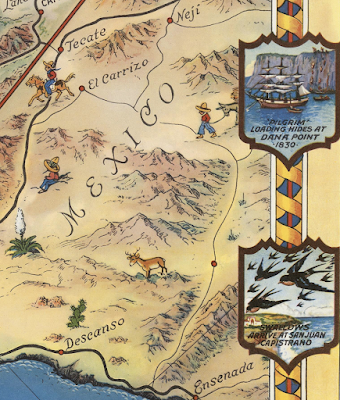
In one of my final posts from my March visit to the La Jolla Map & Atlas Museum, I will show some of their large collection of pictorial maps. They just opened a new room dedicated to these maps including many by Jo Mora, an artist and photographer originally from Uruguay who moved to California, the subject of many of his pictorial maps.
Photo taken at the La Jolla Map & Atlas Museum

Photo taken at the La Jolla Map & Atlas Museum
More on the map above can be found in a previous post.

Another popular collection of pictorial maps is the "Hysetrical Map" series by the Lindgren Borthers.
Photo taken at the La Jolla Map & Atlas Museum
This one is titled "A Hysterical Map Of The Mother Lode Where California Was Born and Hell Was Raised." It's full of jokey details such as "Gold is often found in sand but so is spinach" and "An ass covered with gold has more respect than a horse with a pack saddle." There are also maps of Yellowstone and the Grand Coulee Dam featured on the museum's web page.

A 1963 tourist map of southern California grandiosely titled "Ride the Roads to Romance along the Golden Coast thru the Sunshine Empire of Southern California" shows historic trails emanating out for Los Angeles City Hall,
Photo courtesy of the La Jolla Map & Atlas Museum
to charming mountains, orange groves and historic missions.
Photo courtesy of the La Jolla Map & Atlas Museum
The edges of the map show natural and historic vignettes.
Photo courtesy of the La Jolla Map & Atlas Museum
Harrison Godwin's 1927 map of San Francisco ("where the sun never scorches and the water never freezes") is one of the most detailed pictorials packed with facts, figures, "whimsical vignettes" and transportation info.
http://lajollamapmuseum.org/maps/map-san-francisco-showing-principal-streets-and-places-interest
I was not able to get a good up close photo but here is a screen shot via the David Rumsey Map Collection.
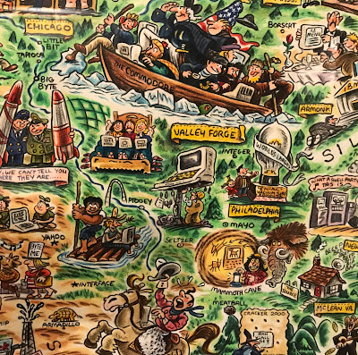
For a slightly more "modern" take here is the "Digital Deli Map of Personal Computer America" by illustrator Rick Meyerowitz, most famous for his work for National Lampoon. The map highlights Silicon Valley culture.
The bottom of the map contains a list of highlighted companies.
Highlights include a hiker in the Cascades carrying a large PC on his back with the screen reading "You are lost" and people in hot tubs looking at their computers. Here is part of the less important and therefore compressed eastern two thirds of the country.


Wednesday, June 5, 2019

America-Lord of the Rings Style

This map was on various other blogs several years ago but somehow I missed it.
https://wallpapercave.com/wp/wp3225883.jpg
Maps in the style of Tolkien are popular these days but I like this one. It was made by reddit user Jvlivs and originally appeared on here on reddit. Some of it is loosely based on Joel Garreau's Nine Nations of North America, though the nations on here are very different. They include a New England that stretches all the way down to Cincinnati,
a huge Missouri,
and a two states comprising the entire western third of the country.
One of the most appealing aspects of this map is the landscape features.
The legend is also a very nice touch.
For a high resolution version click here, for the original discussion on reddit here.