I'm a few days late for National Pollinator Week but here it is...
The map no longer appears to be on National Geographic's web site but here is a more readable image (if you click it for the larger version) from this blog post of the Hampden County Beekeepers Association
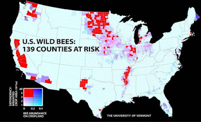
An article in Smithsonian highlights areas where agriculture is at risk due to a high need for pollination coupled with low wild bee populations. The red counties below are the most high risk areas.
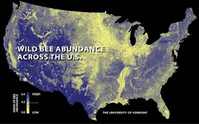
These areas including California's Central Valley, The lower Mississippi Valley and upper midwest are all yellow (low abundance areas) in the map below.
Map of the Day: Published in May 2015, this map explains the importance of bees in our food system. In fact, commercial beekeepers transport these insects thousands of miles around the country every year to pollinate crops when they are in bloom. #MapOTD pic.twitter.com/eKHcb4BBUO— NatGeoMaps (@NatGeoMaps) November 27, 2018
The map no longer appears to be on National Geographic's web site but here is a more readable image (if you click it for the larger version) from this blog post of the Hampden County Beekeepers Association
An article in Smithsonian highlights areas where agriculture is at risk due to a high need for pollination coupled with low wild bee populations. The red counties below are the most high risk areas.
These areas including California's Central Valley, The lower Mississippi Valley and upper midwest are all yellow (low abundance areas) in the map below.


No comments:
Post a Comment