Four Hundred Years Ago this month, the first African slaves arrived on the shores of what would become the United States. The Pulitzer Center's
1619 Project seeks to reframe the history of the United States by using this as a foundational date in the nation's history. This Sunday's
New York Times Magazine is a special issue on American slavery.
The United Nations Educational, Scientific and Cultural Organization (UNESCO)'s
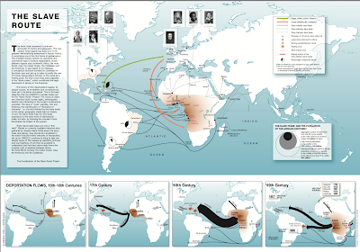
Slave Route project features a good
map of the trade. Click below to load at higher resolution.
The black arrows show human trafficking while colored arrows show the "triangle trade" routes where sugars, tobacco, coffee and cotton were brought from the colonies to Europe (green arrows) and weapons and jewelry (orange) were brought to Africa. Dashed lines show extensive overland and sea routes throughout Africa and Asia.
The smaller maps below show trade volumes of deportation through the centuries. The 17th Century map shows the first, relatively small numbers of slaves sent to the Jamestown Colony.
By the 18th Century that number had grown tremendously.
The numbers shrank for the 19th Century as importation of slaves was outlawed in the United States 1807.


No comments:
Post a Comment