Wednesday, April 26, 2023

Earth Transit

 Earth Transit is a project by Zhaoxu Sui showing the major passenger rail lines of the world.

In his own words "This is the beta version, which means a lot of errors and mistakes could be on the map, please give me corrections and suggestions so that I can improve." Lines are color coded by railway companies. The ambition of this is huge and at this scale it is not possible to show all railway lines in places as dense as Europe,

or maybe China.

There is not an obvious link but you can download a high resolution image by clicking on the picture and saving it or from this link. It's fun (for people like me anyway) to pan around and see what the railway network looks like in places like Central Asia (nice mountains!),

southern Africa,

 and Cuba.

Here are the railways I know and love in my part of North America.
More on the project here. Enjoy!

Thursday, April 20, 2023

Parking Lot Map

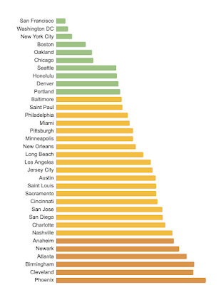
 The Parking Lot Map is a project of the Parking Reform Project, an organization dedicated to climate action, safer streets and housing affordability. The map explores how much land in the central area of the major cities of the United States is dedicated to parking. On average 20% of land is dedicated to parking (this does not include the land dedicated to streets and highways). In Columbus that number is 27%.

The map interface is simple and effective-red parking lots on a gray background. There is a pick list where you can choose a city. Some cities have a "view more" button where you can get zoning details. Here is a map of the Columbus Parking Overlay District.

At the bottom is a graph ranking the cities.

The bottom entry is Arlington, Texas with 42% of its downtown dedicated to parking. The lowest non-suburban city is Las Vegas with 32% of its land as parking. 

Some people would argue that a parkable downtown is a good thing and the cities at the bottom should be considered the best places but charming old European cities like Paris aren't universally loved for their ease of parking. 

The best cities on the list tend to be older ones built out before cars. Washington D.C. only dedicates 3% of its downtown area to parking.

However there are plenty of exceptions. Detroit, the motor city, dedicated 30% of its downtown to parking.


Wednesday, April 12, 2023

America's First Subway Map

The first subway in the United States was built in Boston. The tunnel ran along Tremont Street,  a chaotic mess of streetcars, horse-drawn carriages and pedestrians. The tunnel was built to route the streetcars underground to ease congestion. Here is a plan of the original subway tunnels.

via Leventhal Map Center

The plan involved building a tunnel from North Station to the Boston Public Garden with two portals (where the streetcars emerge from underground) at the southwest end, one at the public garden and another along Tremont Street a few blocks south of the Boylston Street Station. 

This detail shows the latter of those portals, the Pleasant Street portal. Green lines indicate above ground sections while red lines are underground.

The streets in many parts of this plan are unrecognizable as they have fallen victim to various rounds of urban redevelopment. This portal was discontinued in 1962 and was buried underground. The disused tunnel still exists. Here is a detail of Boylston Station showing how the line to the south has to make its way underneath the line that curves to the west (west is up on this plan) making a sub-subway.

A plan showing the progress as of August 15, 1897 (a couple of weeks before its opening) is available from Boston in Transit.

The legend on this map is complicated and hard to translate but the text gives an idea of when various sections were completed.

These subway tunnels are still in use today, part of the MBTA Green Line. For a while this was part of my daily commute to work. The old tunnels are a bit claustrophobic and creepy but they still work!

Thursday, April 6, 2023

The Liverpool Overhead Railway

I found this cool strip map of the Liverpool Overhead Railway, the first elevated electric railway in the world. It opened in 1893 and was dismantled in 1957 because the company could not afford to make the necessary repairs. This map is dated "c1938".

via Flickr

According to the Flickr page, the map was folded into three and placed in a guide booklet. Here is a detail of the downtown area.

The railway served the docks but also billed itself as a "scenic tour" as you could see into the docks from above.

The map is adorned by flags of the various shipping lines and some facts about the railway and dock system. There were 70 docks served by the railway. As a nice touch there's also an arrow at the northern end pointing you to "Sunny Southport"