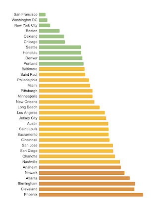
The Parking Lot Map is a project of the Parking Reform Project, an organization dedicated to climate action, safer streets and housing affordability. The map explores how much land in the central area of the major cities of the United States is dedicated to parking. On average 20% of land is dedicated to parking (this does not include the land dedicated to streets and highways). In Columbus that number is 27%.
The map interface is simple and effective-red parking lots on a gray background. There is a pick list where you can choose a city. Some cities have a "view more" button where you can get zoning details. Here is a map of the Columbus Parking Overlay District.
At the bottom is a graph ranking the cities.
The bottom entry is Arlington, Texas with 42% of its downtown dedicated to parking. The lowest non-suburban city is Las Vegas with 32% of its land as parking.
Some people would argue that a parkable downtown is a good thing and the cities at the bottom should be considered the best places but charming old European cities like Paris aren't universally loved for their ease of parking.
The best cities on the list tend to be older ones built out before cars. Washington D.C. only dedicates 3% of its downtown area to parking.
However there are plenty of exceptions. Detroit, the motor city, dedicated 30% of its downtown to parking.


No comments:
Post a Comment