Friday, August 12, 2011

Weekend World Map of Condiments

It's another weekend - so enjoy your local condiment. This map is from Jeff Wysaski's Pleated Jeans site. South Salsa?


Wednesday, August 10, 2011

Public Redistricting Contest

Azavea, a GIS software development company is launching an online redistricting contest for Philadelphia in an attempt at a non-partisan, collaborative process. From techPresident:
Amid Protest Over Closed Philadelphia Redistricting Process, Tech Firm Decides to Start Its Own.


Giving the public a nice and easy interface to make their own districts is a good idea but the City Council can still choose to ignore it. Results will be posted on the Redistricting the Nation website. This site also has a draw your own district interface and lists the Top 10 least compact congressional districts in the country such as Maryland's District 2.


Wednesday, August 3, 2011

Preserving Endangered Languages in Alaska

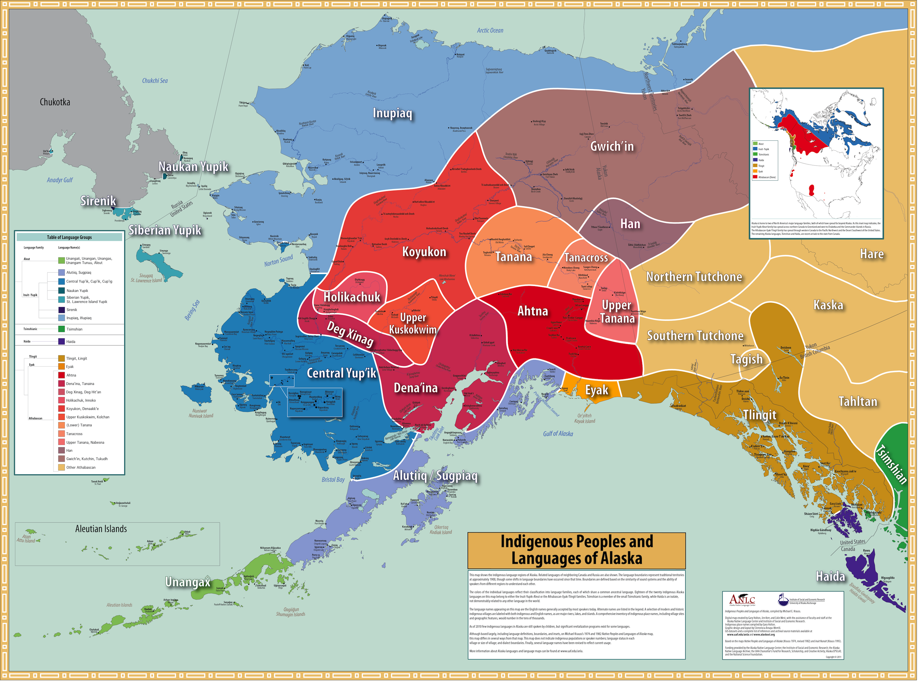
The Alaska Native Language Center in an attempt to preserve indigenous languages has created this striking map of language groups. Some of the languages represented on this map are spoken by fewer than 10 people, others are no longer spoken.


The map is an update of a 1974 map by Michael Krauss that was a result of a linguistic survey focused on variations in pronunciations. Krauss gathered much of his language information from patients at the Alaska Native Service Hospital. There is a detailed history of this and previous Russian and American maps on the Resources pages from the Center's website.  There is also a detailed discussion of the sometimes controversial choices made for language names and spellings. Interestingly many of the language names translate to mean either "people of this region" or "real", "true" or "genuine" person.

The Resources pages also provide guidance in giving your dog a traditional Native Alaskan name. Some examples:

maguyuk  'howler'
pakak  'one that gets into everything'
pamiiruq  'wags his tail'
pukiq  'smart'
qannik  'snowflake'
qimukti  'puller'
tupit  'tattoo lines on face'
pukulria  'bone chewer'
yakone'  'red aurora'
shtiya  'my strength' 

Friday, July 29, 2011

Map of the Weekend-Riding the Hubway

Yesterday Boston finally caught up to Washington, DC and Minneapolis and started a bike share program - the Hubway. They have an interactive map showing the stations and availability of bicycles at each one.

Currently the system serves limited areas but they plan to expand it into Cambridge, Somerville and other neighborhoods in Boston. I have not had a chance to try it out yet (as I did in Montreal - see the comments section from this post) but the Boston Globe did and posted this somewhat unfair article where they raced it against the subway and a taxi. In addition to the indirect route the bicyclist took, she also needed to purchase a membership pass. I've cycled on those streets and find it hard to believe that it would take half an hour to get from the library to Bobby Orr. Anyway the graphic is well done.


If you're in town give it a ride. The streets are not ideal for cycling but it's still the best way to see a new place or get a new perspective on a familiar one.

Wednesday, July 27, 2011

Map of the Week - Netflix

I was going to post something more intellectual than this but today's a busy one so here's something nice and dumb- a map of what Netflix considers to be popular in your state courtesy of Slacktory.


Friday, July 22, 2011

Map of the Weekend-Sweet Mappy Dreams

The best way to end a Detroit map week is to fall asleep on a nice Detroit River Pillow from the SaltLabs.


Or you can choose from a range of other nice designs. Sweet Dreams!


Tuesday, July 19, 2011

Detroit - the Woodward Plan

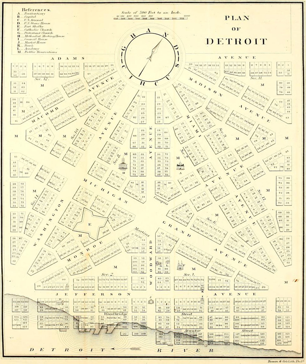
There's a lot of good cartographic content on flickr. I was looking for something else on a flickr group titled The Paper Cites- Speculative and Unbuilt Structures, when I came across this image from a user who calls himself whitewall buick. It shows the "Governor and Judges' Plan" for Detroit after the1805 fire destroyed the city. This plan was based on L'Enfant's plan for Washington DC with a series of plazas and wide boulevards radiating outwards. The shaded area is what was actually implemented.

According to the poster, the remaining areas grew haphazardly because the city was not given the authority to force private landowners to subdivide their land according to the plan. Unfortunately much of the content on flickr is poorly attributed and he does not give much more information.

Here is a map the current street network (and what was ruined) from Detroit Yes! I suspect this map is a bit out of date because it does not show the Campus Martius Park (see below.)


Michigan Territory Chief Justice Augustus B. Woodward proposed a plan of hexagonal blocks with the Grand Circus as the central point.


The Campus Martius, a few blocks south of the Grand Circus, is the point of origin for Michigan's coordinate system of roads that includes the Seven and Eight Mile roads located at those distances away.

Here is a photo of the point of origin marker. Campus Martius Park has recently been redeveloped into a very popular city park with fountains, performance spaces and an ice skating rink.