Wednesday, June 23, 2021

The Southern Underground Railroad

Mexico outlawed slavery in 1829. Texas fought for independence from Mexico in part to be able to reestablish slavery there. For those seeking freedom from Texas and other nearby states Mexico was a much closer destination than Canada. It was a much tougher trip than for those who went north without the support and protection available in free states. Most who tried to escape to Mexico likely never made it. Still Stephen F. Austin State University's Texas Runaway Slave Project has documented over 2,500 escapees.

Illustration by Erwin Sherman via Texas Highways 

Runaways may have been helped by Mexican immigrants, German settlers who were opposed to slavery and by their own skills at horseback riding. Crossing the Nueces Strip, the hot, arid land between the Nueces River and Rio Grande was particularly difficult but with a horse and a gun, it was possible. 

Once in Mexico there was still much adversity with few job opportunities, a language barrier and little local support. Still it was better than being enslaved. 

Without a major support network there are not established routes to map, just general flow patterns as seen on the map above. This map that commonly appears on the web shows a general flow southward through Texas in addition to the more commonly known routes.

via Pinterest

 More info at Texas Highways

Thursday, June 17, 2021

Vaccine Deserts

 A new vaccine equity planning tool has been launched by Ariadne Labs. It shows vaccine deserts, defined as areas with limited access to vaccinations. You can pick a state or zip code and see where these are. Here is Ohio.

There is a pretty clear pattern of rural areas having the least access. In contrast, earlier in 2021, there were rural and urban deserts as detailed by a Deloitte study quoted in the Missouri Independent. Here is a map showing (in blue) the deserts of Missouri,

Images via the Kansas City Star

and a close up of Kansas City.

The Ariadne tool is designed so that planners can advance their outreach to the areas most in need. From their web page.

“Vaccines are now increasingly available across the U.S., yet there is still a population struggling with access. Not everyone has the ability or time to spend an hour out of their workday or more to get their vaccine. By accounting for different modes of transportation — including public transit and walking — we hope public health officials and providers will gain a deeper understanding of how to reach all communities,” said Katherine Chou, Director, Product Management, Google Health.

Some of these deserts are in empty, disconnected, or wet areas such as this spot on the coast of Maryland so the tool is imperfect, like everything in mapping.


Wednesday, June 9, 2021

The Cold War in the Heartland

Cold War in the Heartland is a project of the University of Kansas Center for Russian, East European, and Eurasian Studies.

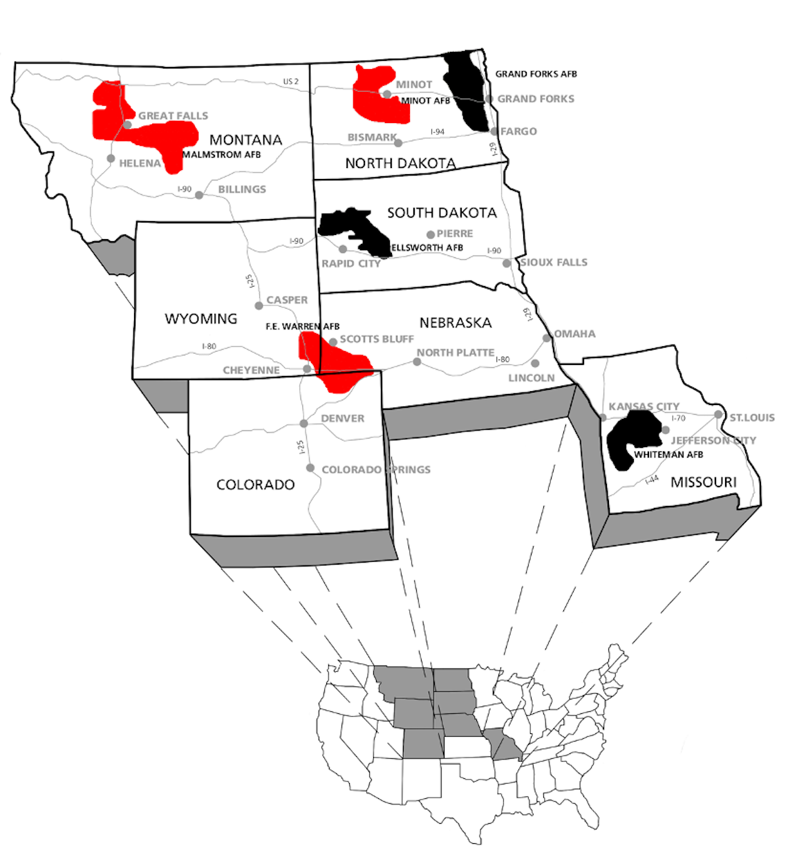
Durng the Cold War Intercontinental Ballistic Missile (ICBM) silos were placed throughout the United States, particularly in the upper Midwest. This map shows missile fields that are still active in red and ones that have been deactivated in black.

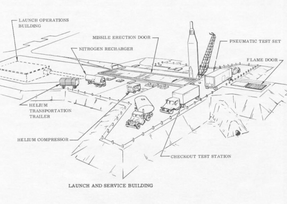
Here is a diagram of a typical missile site.

Topeka Regional Airport, formerly Forbes Air Force Base, became the home for an Air Force unit that conducted nighttime photography and mapping expeditions over Russia and other communist nations. In 1959 the Strategic Air Command ordered nine ICBM sites built surrounding the base. These were decommissioned in 1965 after the costs to maintain them became too high.

A description of the site at Worden Kansas (548-2 Lawrence) on the map above.            

"Today, weeds, bushes, and trees cover nearly the entire site and frogs cheerfully leap into the pond that has formed in front of the entry door to the old missile bay. At first glance, it appears that the site, once at the forefront of the nation’s nuclear arsenal, has been reclaimed by nature. Yet is still possible to recognize a few of the launch facility’s features, such as the different buildings and the doors that allowed the missile to be launched. These remnants speak to the profound environmental impact of the nuclear arms race, one that can still be felt today."


Monday, May 31, 2021

Reconstructing Greenwood's Past

A hundred years ago a thriving black neighborhood of Tulsa, Oklahoma was destroyed by a white mob. The New York Times has done an excellent job of recreating what was there piecing together old maps, photos census records and other archives to create maps and a 3D model.

Images via New York Times
This is a "scrollytelling" piece - you scroll through the page to get a tour of the neighborhood including 3D buildings, pictures and maps.

The screen shot below illustrates the extent of the damage - only part of the map is shown here, for the entire map and text go to the article.

This Sanborn Insurance Map from 1915 - via the Library of Congress gives some idea of the character and prosperity of the neighborhood before it was destroyed. 

While much of the neighborhood was rebuilt and thrived for a second time, it was destroyed again, this time by urban renewal. An aerial photo via Google Maps shows a neighborhood of expressways, parking lots, empty land and a baseball stadium. 
 
To take the tour visit the New York Times. There is also a detailed map (featured previously here) from the Tulsa World.

Wednesday, May 19, 2021

Herring Run

I took a bike ride with a friend the other day to Horn Pond in Woburn, Massachusetts to watch the Herring make their annual journey upstream to spawn. They swim upstream to lay and fertilize eggs in freshwater streams and lakes and then return to the ocean. The young grow and mature in fresh water and then head out to the ocean in the fall. 

There are several dams blocking their passage but there are also fish ladders up to the dam at the south end of Horn Pond. There is a narrow passageway up this dam. We talked to some watershed association volunteers who were counting fish and they were hoping to improve the passage into a more formal fish ladder. As it is now many fish get stuck under the impassable part of the dam. While we were there two people came with large nets and were scooping huge numbers of fish from under the dam and tossing them into the lake above the dam.

Here is a video I took of fish waiting to climb up to the pond.


On the way back we stopped at the fish ladder at the Center Falls Dam in Winchester which has some informational displays including the map above. Unfortunately because of the grate covering the ladder you can't really see the fish. Here is a map of the entire watershed via the Mystic River Watershed Association.


Wednesday, May 12, 2021

Cicada Invasion

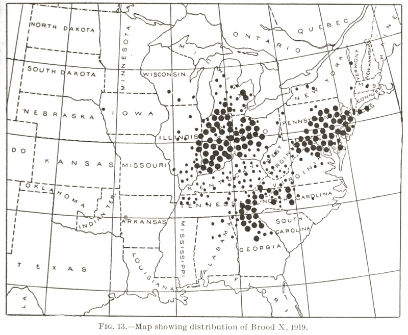
In the next few weeks Brood X cicadas will emerge from underground as part of their 17-year life cycle. They will fly up to the trees, mate and from my childhood memory, make a ton of noise. This charming 1919 map from the US Department of Agriculture, Bureau of Entomology shows the distribution of this brood then - via Cicada Mania.

The University of Connecticut has an updated, interactive map showing a very similar distribution. I guess they don't like the northern Appalachians.
The large cicada symbols are verified records while the smaller ones have a lower degree of certainty.

A huge swath of the country is about to get noisy!


Wednesday, May 5, 2021

Hysterical Map of South Carolina

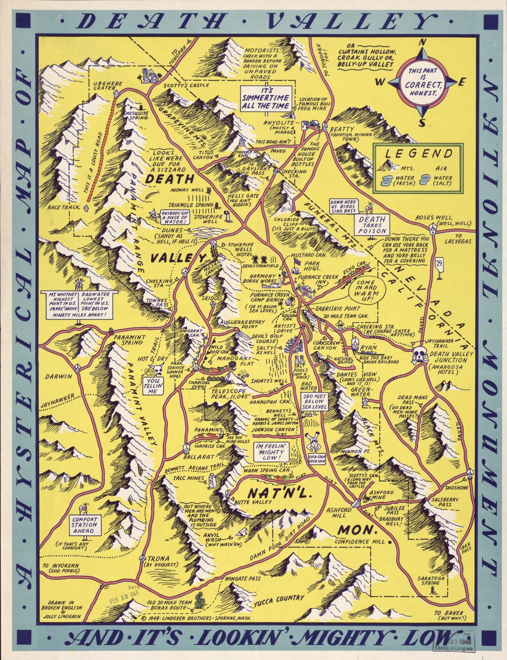
Not to be confused with the Lindgren Brothers maps (one is featured on this blog post) this "hysterical map" predates them a bit. 

This map was drawn by Irving Geis (born Geisburg), a New Yorker with family roots in South Carolina. He spent time in that state as an art student before becoming a scientific illustrator. The map first appeared in the 1932 edition of the University of South Carolina's yearbook. The above image is from a much later third edition. The original had less color but more prohibition jokes - note the liquor bottles lining the 12 mile coastal limit.

Image via Barron Maps

Like the Lindgren maps, these maps are full of puns and caricatures that might not hold up very well today. I'm not sure what the Iodine issue is in the image at the top but it was in the cows and the vegetables. Some nice touches include the magnetic/pathetic north arrow,

the ancestor worshiper, "not dead (unfortunately)",

and the non-angel in the upper left corner.

The scale of the map is listed as 5 miles to the gallon and the politicians are sleeping outside the Capitol Building in Columbia. You can view the third edition here

It is not clear how much the Lindgren Brothers may or may not have taken their ideas from this map but they are very similar-as seen here.