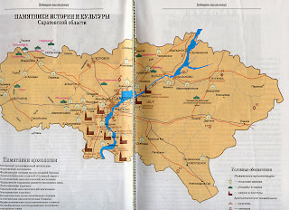
Nine churches are identified on this double-page map titled "Monument Map" which was taken from "Treasures of the Russian land; Quarterly Journal of the All-Russian Society for the Preservation of Cultural and Historical Treasures", Artist: G I Metchenko Nr 40- (3-4/1998) [in Russian language only, out of print].
Legend: Green tents represent palaces, grand manors, estate parklands. Pale churches with round roofs represent Russian village churches. Brown churches with steeples represent German (Lutheran, Catholic, Reformed) churches. Other symbols shown include: Six-pointed stars representing archaeological sites (these are not Jewish sites). The six-pointed star is labeled as "stoyanka" - meaning "stopping place" for the "first inhabitants", the three pebble stones represent burial mounds, open boxes representing burial sites (tombs), squares representing ancient town sites, wheels representing ancient settlement sites. Map contributed by Vera Beljakova-Miller.

from http://www.volgagermans.net
