
As we prepare to spend Thanksgiving with my wife's family in western New York, here are some maps of what we could be in for. This one, posted on Flowing Data a few years ago does a nice job of showing the lake effect snowbelt south of Buffalo. But there are problems...
 Green implies that the rest of the area including Buffalo (inside the dashed box) is not so bad. However, a look at the legend shows that green is up to 80 inches a year and the yellow that appears in many of the suburbs is 90-100 inches. Chautauqua County people may consider 80 inches to be minor but for the rest of us this color choice is terribly misleading.
The map also may need an update as parts of the region are getting half their average this week.
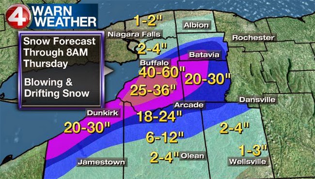 Be "4 Warned" - this is another misleading map. How much snow will we see in Rochester? Apparently nothing even though family members tell us otherwise. The dropoff from 18-24" to nothing at the Livingston-Wyoming county line is remarkable as is the sudden lack of snow in Erie County, Pennsylvania. No data and no snow are not the same thing so don't treat them the same.
The map also may need an update as parts of the region are getting half their average this week.


No comments:
Post a Comment