Ohio's boundaries seem so "regular". Three straight lines, a river and a lake. That regular form though is composed of many irregular pieces, each with their own history. I came across this map and Wikipedia entry, while looking for something completely unrelated and was intrigued enough to dig a little deeper.
Many of these "purchases" and "agreements" involved forced displacement of Native Americans, wars, massacres, bad faith treaties and swindles. Here are a few examples.
The Connecticut Western Reserve were lands claimed by Connecticut. That colony's charter included a "sea to sea" provision, giving it all lands within the state's latitude all the way to the Pacific Ocean. The claims in Pennsylvania and west of Ohio were ceded after the Revolutionary War but the "Western Reserve" of Ohio was held onto for another 14 years. This area included the "Firelands" at the western edge. These were lands given as restitution for residents of numerous Connecticut towns that were burned by the British during the war. The terms "Firelands" and "Western Reserve" are both still commonly used today.
Just south of this, the small uncolored area represents the Moravian Indian Grants, lands that were granted to Christian Indians who had been converted by Moravian missionaries. These grants were made as reparations after 96 of them were murdered in the 1782 Gnandenhuteen Massacre under the false notion that they had participated in killings of settlers. As these natives were driven further west, the land was bought back and sold to white settlers. These lands were not surveyed in the usual rectangular pattern leading to some interesting shapes.
To the west and south much of the lands were sold as rectangular tracts in the township and range pattern. The small green square in the northwest is the Twelve Mile Square Reservation surrounding Fort Miami, a fort built by French settlers on the Maumee River. It was rebuilt by the British to help the natives fight U.S. settlers in the Northwest Indian War. This war, begun in 1786 eventually resulted in the displacement of most indigenous people from Ohio.
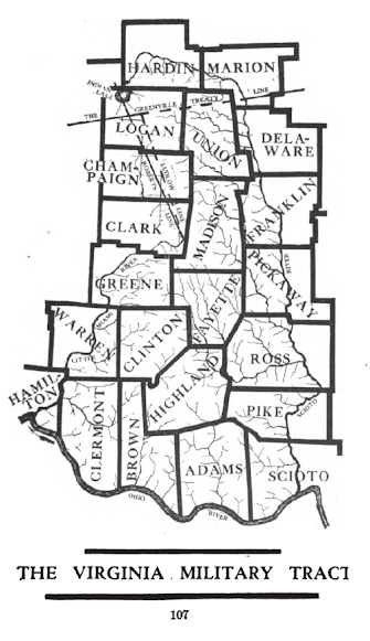
Like Connecticut, Virginia also claimed lands far to the west of the state including areas of Ohio. Before there was a state of West Virginia, Virginia shared a boundary with Ohio. The large green area in the southwest were lands that Virginia granted to veterans in lieu of cash for their service in the Revolutionary War. The boundaries of this district were contentious and a line separating Native American lands from lands open for white settlers was ambiguously drawn in the Treaty of Greenville, leading to more unrest. Here are the counties included in the Virginia Military District.
The small unmarked and unshaded area near the bottom tip of the map is the "French Grant",
granted as compensation to French settlers after a series of worthless
land deeds were sold to them by a company that did not own the land.
Finally, the northernmost pink area is the Toledo Strip. This area was claimed by both Ohio and Michigan and fought over in a "nearly bloodless" war. Both states deployed militias on opposite sides of the Maumee River near Toledo, but besides mutual taunting, there was little interaction between the two forces. The single military confrontation of the "war" ended with a report of shots being fired into the air, incurring no casualties. The war was resolved in 1836 with a compromise, allowing Michigan to claim three quarters of the Upper Peninsula in return for giving up its claim on the Toledo Strip.


No comments:
Post a Comment