Thursday, November 30, 2023

Thirty Day Map Challenge 2023-Days 24-30

The final installment of this year’s 30 Day Map Challenge. 

Day 24 - Black and White


I had no thoughts ahead of time on this one. I wanted to do something with raster data and the easy, quick thing (this often requires taking the easy and quick route) was to grab the Natural Earth dataset that I already have (used for Day 21) and play with the lighting and contrast to create this nice looking map of the Canadian Maritime provinces (excluding Newfoundland).

Day 25 - Antarctica

I had been working on a ggplot (an R software package, Wyoming on my Day 9 map) tutorial and knowing Antarctica Day was coming up decided to try it. I had also recently been to a talk about using Chat GPT for making maps so when I wasn’t satisfied with my result asked it to write me some ggplot code.

My first ChatGPT map!
It’s quite simple but I got exactly what I asked for. However when I asked to add the territorial claims of various countries, it pointed me to some data that is not available and when I got my own data (with help from Chat GPT) I was not able to add it correctly so I went back to QGIS to help me make this map.


I was hoping to convey a sense of fatuousness about these claims. I outlined the UK claim in blue dashes because it overlaps with so many others. Argentina (overlapping Chile, Brazil and the UK) was accidentally deleted from the map.

Day 26 - Minimal

I’ve enjoyed this category in past years though this is probably not a very literal definition of minimal. Various ideas came and went when my map started looking like one of those Portolan Charts of old so I went with it.


I started out with a other water bodies but Lake Erie seemed to meet the criteria best so here it is.

Day 27 - Dots


Massachusetts town centroids. This was a bit of an experiment to see what drawing only the points would look like for a state with a very unique shape. Many years ago I worked for the state Commonwealth and I still had some data floating around. I don’t know about other people but this map plays tricks on my eyes. I see outlines even though there are none.

Day 28 - Is this a chart or a map?

Some maps should just be shown as charts and that is the central idea of this prompt. Instead of delving into that, with limited time I recycled a jokey thing I put on Twitter years ago with a few modifications. The original tweet was about Pennsylvania’s width by longitude, here is the chart (map).


I followed it up with the Vermont/New Hampshire one. The Delaware maps I made this month were another take on this idea.

Day 29 - Population


Here is a good learning experience. China has a large number of cities with populations over 2 (actually 10, keep reading) million. Most of them are unknown to people in the western world. Any one of these cities would be in the top 5 in the United States by city population. The metropolitan area populations might be more comparable but still by that measure most of these cities would be in the top 10. I realized after making this map that my population figures are out of date and there are actually 17 cities with a population over 10 million (via Wikipedia, 2021 data). Some of these cities have come close to doubling their population since the 2010 census, which is probably where the figures on this map came from. If (or when) I have the time, I should remake this map with the current figures. 

Day 30 - My favorite…

I struggle a bit with picking favorites - there’s usually multiples for any category and they change frequently. One of my favorite things in the world is chocolate so here is a map titled “The Chocolate Mountains of Africa”


These are cocoa harvesting areas from Earthstat. I used the magic of GIS to show the areas as if they are mountains and then did a little photoshopping to improve the colors. About 60% of the world’s chocolate is produced in two neighboring countries; Cote d’Ivoire (Ivory Coast) and Ghana (source). This is not well conveyed on this map unfortunately.

Wrap Up

That’s it for another year. A few days into the challenge I posted this to my social media accounts:

"The #30DayMapChallenge stages of denial: 

I will not participate in this year's #30DayMapChallenge

OK, but I won't take it too seriously Maybe I'll only do a few of them 

Ok, but I'm not going to lose sleep over this 

It's 4 AM and I'm thinking about hexagons 😵‍💫"

After a while I got into a nice rhythm with this and I will really miss making a map every day. I’m not sure what will happen when I wake up tomorrow confronted with the emptiness. Maybe I’ll sleep better. Anyway, thanks for reading a month of self-indulgent posts (lots of sentences beginning with “I”) and next week it will be back to hopefully more meaningful content.

 Apologies for the uneven fonts and text colors in some of these posts. This old platform has been giving me formatting fits lately. I've tried to keep the colors and the fonts consistent but in a post this large it's very hard to do.


Friday, November 24, 2023

Thirty Day Map Challenge 2023-Days 17-23


Another week of 30 Day Map Challenge Maps…

Day 17 - Flow

Probably the intention here was to have people make maps of the flow of surface water or air or traffic but I decided to make a flow chart instead.


A vaguely interesting look at the trip home I had to make many times as a graduate student at the University of Kansas. Take the longer route through the hills or stick to the direct path through some remarkably dull, flat scenery (my opinion-some people appreciate flatness). If you get off the interstates those parts of Illinois and Indiana are probably much nicer to look at but highway blandness coupled with unremarkable terrain makes for one sleepy drive. The southern part of Indiana is quite a bit nicer to drive through as are Kentucky and West Virginia.

I used Felt and their extract tool to get the state outlines and then break them apart. The outlines are a bit caricatured but I like that look for this purpose.

Day 18 - Atmosphere


What’s in the atmosphere? Pollutants. What is a primary atmospheric pollutant? Ozone. What is one of my favorite names for a neighborhood? Ozone Park in Queens, New York. The map is mostly reproduced from earth.org.

Day 19 - 5 minute map


Just a quick map drawn with colored pencils on graph paper. If you look closely there’s a mistake on the west side of town!

Day 20 - Outdoors

 We usually spend a week or more of summer in the Midcoast region of Maine so for the outdoors theme I chose boat launches. This map might even be useful to me next summer!

Day 21 - Raster


Here is another lost learning opportunity. I work infrequently with raster data and could have spent some time learning some new tricks. Time intrudes though so here is an image from the Natural Earth dataset with tweaks to the colors, transparency and blend modes. I like what happens in the mountains of Pakistan.

Day 22 - North is not always up


Rehashing the (sort of ) joke from Day 13 but oriented towards the Orient (specifically Jerusalem) like the maps of old. This is a terrible mismatch of antique style and modern map but so be it.

Day 23 - 3D

Lacking a better idea I took the Delaware joke one step further. When busy traveling for a major holiday one needs to economize on data.

Thursday, November 16, 2023

Here is another week of work for this month’s 30 Day Map Challenge.

Day 10 - North America


I’ve been looking at a tree identification guide and was inspired by the map in the book. I also thought this would be a nice time to get out the watercolor pencils. The colors didn’t blend as much as hoped-I probably didn’t use enough water or the right kind of paper.


Day 11 - Retro


Going for the 1950’s geography textbook look hopefully with some success.

Day 12 - South America

These animals have overlapping ranges so I highlighted the ones with the smallest ranges. Alpacas (in the wild) live mainly in the high mountains. This map features my first ever llama north arrow.

Day 13 - Choropleth

Choropleth is a somewhat map jargon-y term referring to discreet areas, usually classified in some way. For example, election maps. Usually there would be many areas classified into categories so choosing a state with only three counties and one for each category doesn’t really make this a true choropleth.

Day 14 - Europe

This was an experiment in playing with a space theme and showing some discreet countries that don’t have much in common other than being at the edges of the continent.

Day 15 - OpenStreetMap

I went with my default Openstreetmap mode of finding some random item (gas stations) and picking a random location. This could have been a much better learning opportunity as there are many other ways of working with this huge data set and I really do need to learn more about it. However, life intrudes and I didn’t have the time so I chose a quick subject and location. The logos are from the six most prevalent gas station brands.

It turns out Paraguay has the most per capita gas stations of any country in South America for various reasons (source) so this map is almost unreadable. I also learned that Petropar is the country’s national oil company while Petrobras is a Brazilian company.

Day 16 - Oceania

 Every other continent gets a day this year so why not Oceania? Here are the roads via the Globio Roads database. I’m not sure why the network in New Zealand is so much denser than anywhere else but there it is. I like the way you get a basic population and country shape map by showing roads and nothing else.


Thursday, November 9, 2023

30 Day Map Challenge 2023 Days 3 9

Here’s what I’ve been working on for the past week’s 30 Day Map Challenges with the prompts listed.

Day 3 - Polygons

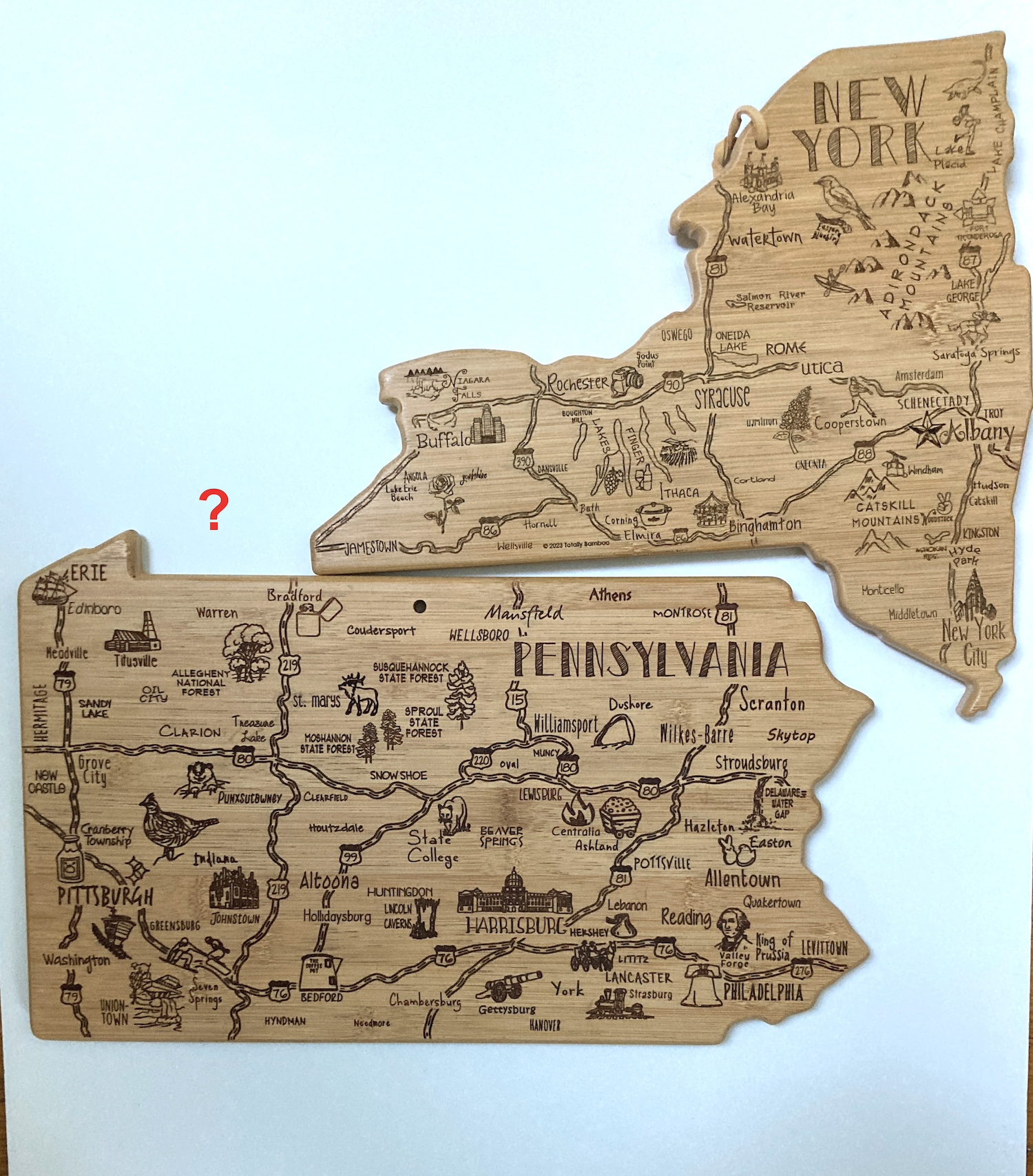
This is not exactly a hand made map, more having fun with cutting boards. My wife gave me the Pennsylvania board a few years ago and I used it in the 2021 challenge as seen here-a map of GDP by metropolitan areas. 

Her brother just gave me the New York version and hey, they don’t fit together. I guess I shouldn’t expect them to be scaled - the Delaware version would only fit a clove of garlic.

Day 4 - A bad map

A map of Lake Okeechobee zoomed way too far in. Could be any lake but Okeechobee is a great name. There could be a lesson here about maps losing their utility when you’re too far zoomed in or maybe it’s just a cheap lazy joke.

Day 5 - Analog (ie map without a computer)


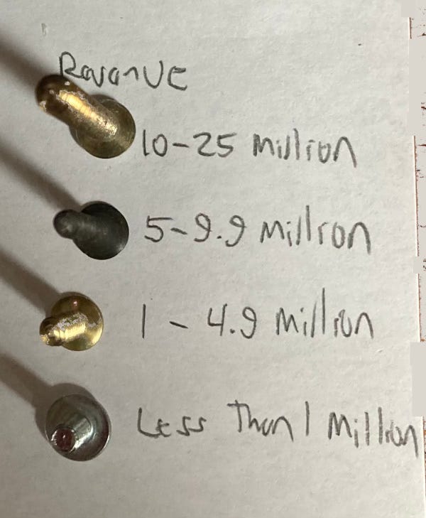
Screw manufacturers. I had an idea in at night when not sleeping about doing a map of nail manufacturers in the USA. The idea came to me because as a college intern in Albany doing local property history I found that there were many nail shops in my neighborhood. It turns out that most nails are imported now. So I did screws instead. The data source (Thomas) is biased towards their featured products but there’s contradictory info online and I needed one stable list. 

Here is the legend from a readable angle.

Day 6 - Asia

Album covers by the band Asia, who of course are from England. I don’t love how they turned progressive rock into pop treacle but their album covers are wonderful. There are more informative topics out there but this one was fun to do.

Day 7 - Navigation

I have a friend who has organized a somewhat yearly pontoon boat ride down the Parker River in Newbury, Massachusetts and into Plum Island (really a peninsula) Sound. This year we got stuck on a sandbar. That was the inspiration for this map.

Day 8 - Africa

Where do African violets come from? From the Eastern Arc Mountains of Tanzania and Kenya. The version I posted on social media had a small error in the southernmost region. This version is more correct.

Day 9 - Hexagons

States of the US as RStudio hex stickers. Hex stickers are a cultural phenomenon among users of R software. They are for different modules (not sure if that’s the best word). I don’t know much about R and but you can make maps with it using the ggplot module (see Wyoming above). If I were a better software user I would have made this map in R but I didn’t have time to figure that out.

I tried to make some logical choices here. Maine is the lobstr module, California has a seal and Kansas has a yellow brick road.

Probably more to come next week as I can’t seem to stop myself….