Here is another week of work for this month’s 30 Day Map Challenge.
Day 10 - North America
I’ve been looking at a tree identification guide and was inspired by the map in the book. I also thought this would be a nice time to get out the watercolor pencils. The colors didn’t blend as much as hoped-I probably didn’t use enough water or the right kind of paper.
Day 11 - Retro
Going for the 1950’s geography textbook look hopefully with some success.
Day 12 - South America
These animals have overlapping ranges so I highlighted the ones with the smallest ranges. Alpacas (in the wild) live mainly in the high mountains. This map features my first ever llama north arrow.
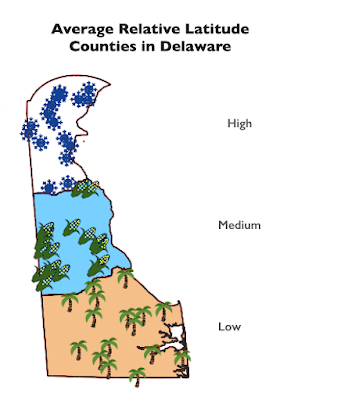
Day 13 - Choropleth
Choropleth is a somewhat map jargon-y term referring to discreet areas, usually classified in some way. For example, election maps. Usually there would be many areas classified into categories so choosing a state with only three counties and one for each category doesn’t really make this a true choropleth.
Day 14 - Europe
This was an experiment in playing with a space theme and showing some discreet countries that don’t have much in common other than being at the edges of the continent.
Day 15 - OpenStreetMap
I went with my default Openstreetmap mode of finding some random item (gas stations) and picking a random location. This could have been a much better learning opportunity as there are many other ways of working with this huge data set and I really do need to learn more about it. However, life intrudes and I didn’t have the time so I chose a quick subject and location. The logos are from the six most prevalent gas station brands.
It turns out Paraguay has the most per capita gas stations of any country in South America for various reasons (source) so this map is almost unreadable. I also learned that Petropar is the country’s national oil company while Petrobras is a Brazilian company.
Day 16 - Oceania
Every other continent gets a day this year so why not Oceania? Here are the roads via the Globio Roads database. I’m not sure why the network in New Zealand is so much denser than anywhere else but there it is. I like the way you get a basic population and country shape map by showing roads and nothing else.


No comments:
Post a Comment